A short tour in North Iraq:
 Technical Comment
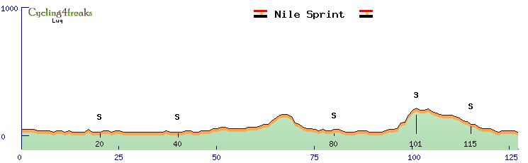
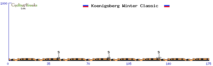
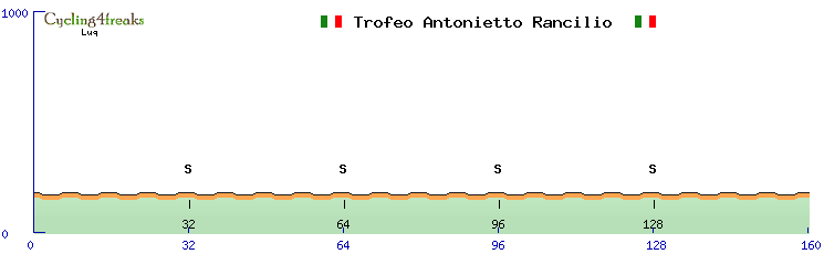
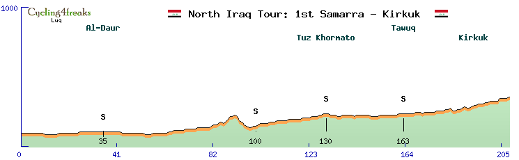
10km min-tact, the sprint is on+1, the road costantly goes up slowly. No sieb kms. So it should be easy for sprinters, but 208km won't be easy to manage and maybe an attack from a finisseur can go through!
Roads
We start from Al Azzawy Street, then at km5 we go throug ancient Samarra. This is how the road will look like:
http://www.panoramio.com/photo/53892790
Then we pass the Shinasi Walls, and go on straight admiring some of the beauty of Ancient Samarra. Then on Al-Daur (place famous cause there was captured Saddam) at about km 32, and there we move on the right (
http://www.panoramio.com/photo/61083472). Then you won't find much till km70 where we turn on the right, mostly sand!
On km 97 there is a bridge, be careful. Then we go on till the city of Tuz Khormato and we turn left there (gave a look at the mosque
http://www.panoramio.com/photo/31762905, this is our road
http://www.panoramio.com/photo/58987529).
Then Tawuq (
http://www.panoramio.com/photo/58987529) and then to finish Kirkurk following Baghdad Road with a beautiful ending on the Citadel Garden (
http://www.panoramio.com/photo/82138052,
http://www.panoramio.com/photo/38885607)
Second Stage
 Technical Comment
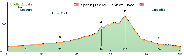
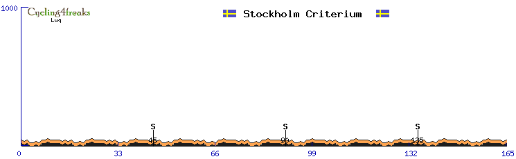
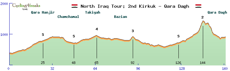
We move things a bit, min-tact of 31km on a short stage of 161km. The profile looks good for a classic, the final hill where the action will happen starts with a +6 then goes up slowly but became a lot difficult on the last 4kms +7 +10 +11 +11, may some climbers try the attack there or sieb? This day will open also the hunt for the red jersey, good luck! For a closer look ->
http://www.radsportfreaks.de/radsport/p ... radagh_luq
Roads
We left yesterday on the Citadel Garden. And today we start with the Imam Qasim Garden (here the street
http://www.panoramio.com/photo/21717192 , unfortunately don't have an image of the garden

). So we leave the city, at km3 we are already out, houses will be few (leaving the city:
http://www.panoramio.com/photo/26007869). Funny info, at km8 we will see the Chiman Park, something like a circus in the plain desert!
http://www.panoramio.com/photo/93803536 .
Then always following the street (
http://www.panoramio.com/photo/87998291) we arrive at km25 IS at Qara Hanjir, road is going up, we don't enter the city just pass aside. (
http://www.panoramio.com/photo/27073878). Then we go slightly down always following our route (
http://www.panoramio.com/photo/37274553) and passing Chamchamal city not entering it and continue going to east. At Bazian at km 80 we take direction into South, there we start to see the mountains we will climb. This is the beauty of that places
http://www.panoramio.com/photo/39626588 ,
http://www.panoramio.com/photo/20764119 ,
http://www.panoramio.com/photo/20761404 .
At km 114 we face a cross, and we turn left, following that street for about 20kms, roads goes up, then again left, we are there, hill begins (
http://www.panoramio.com/photo/73833632)! The roads there in some part is dirty, so a bit of sand could be in street. Finally we go down, knowing that big mountains still wait us!
Third Stage
 Technical Comment
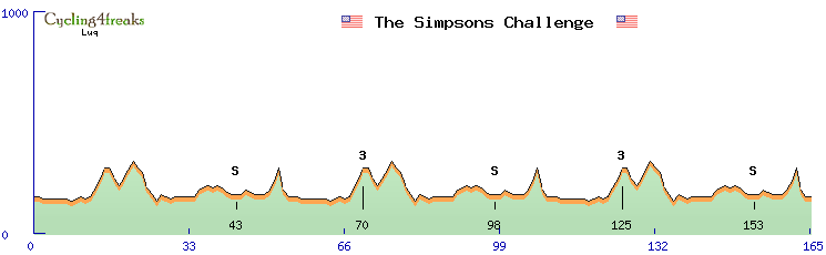
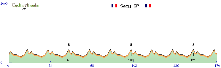
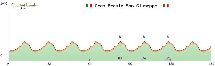
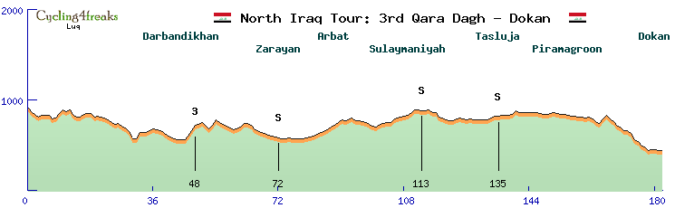
Another flat stage, or at least classified as flat. 182km overall, min-tact from km 162, just before the last hill (a +4 +5) where some attacks could be made, profiting of the tough and long downhill sections were good flat riders won't gain that much. At the beginning some sieb kms (especially +6 +6 where there is the 3rd CAT GPM) but too distant to be really a problem for sprinters, so at the end the bet is for a sprinter or for a lucky escape (
http://www.radsportfreaks.de/radsport/p ... _dokan_luq).
Roads
The race of the two lakes! We will go South to Lake Darbandikhan and then North to Dukan lake. We start (here the start road
http://www.panoramio.com/photo/73833566) where we finished yesterday, and we move to south, the beginning it's full of up & downs (
http://www.panoramio.com/photo/87095660 and again
http://www.panoramio.com/photo/41914871 and again!
http://www.panoramio.com/photo/22370699), good occasion to sieb, after there won't be many. We finally arrive to Darbandikhan (
http://www.panoramio.com/photo/21582905) at km44, we enter the city and pass the Darbandikhan Tunnel (
http://www.panoramio.com/photo/21583493) to go on the right side of the Baranan Mountain! Here the first lake
http://www.panoramio.com/photo/6762217.
Now the difficult part of the stage is gone, we go to the North % became lower, and sprinters can start their work. Then km72 Zarayan, speed will be a bit high here, but not much to see anyway
http://www.panoramio.com/photo/85590484 . Still proceding our march to North on km 87 we find Arbat and continue following the street (look the beautiful Arbat Gardens!
http://www.panoramio.com/photo/14892838). Finally at km 109 we enter Sulaymaniyah, go to the city centre, we pass Azady Park (
http://www.panoramio.com/photo/80177574) then go down to Zargata Hill then back on the Kerkuk road again till Tasluja where we move right and do 40kms to reach Dokan at our side the river that goes into the lake (going down to Dokan
http://www.panoramio.com/photo/45410207 , the river
http://www.panoramio.com/photo/59153711)
Just one more thing, we pass also Piramagroon, a mountain that deserves a photo as well
http://www.panoramio.com/photo/69839292
Fourth Stage A
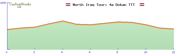 Technical Comment
A TTT, 12km but quite tough
http://www.radsportfreaks.de/radsport/p ... =dokan_ttt . After the second stage we didn't have nothing to open the GC, so we decided before the "Great Finale" to shake the gc classifications, some will go fast here, other a bit slower but the difference will be not so huge to be not reversed in the stage b. Energies should be not a great problem for stage b, but it will weaken especially helpers.
Roads
Beautiful panorama of this city which is just in front of the lake. These are the streets we will do
http://www.panoramio.com/photo/65336971 , up and down through the green. (Another thing who got my attention is this
http://www.panoramio.com/photo/85547822 
)
Fourth Stage B
 Technical Comment
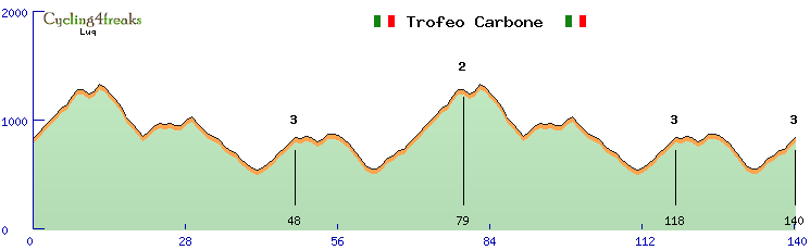
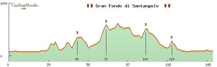
Short race but really tough, mainly for two reasons 1) the TTT before, 2) The difficult weather conditions. No space for early escapes i guess, early siebs are quite probable, from Zazla every km is good for the winning attack, the leader must be careful for every possible attack. This stage will be very expensive in terms of energies, let's see what will happen. Long min-tact 31kms but the stage is quite short.
Roads
We start again from Dokan moving to North East, first climb, difficult but rideable
http://www.panoramio.com/photo/87871759 , it's only the prologue of the stage; beautiful panorama over the Dukan city from there (
http://www.panoramio.com/photo/21499034)!
Then the second mountain, much more steep, much more difficult, the green slowly let the space to the yellow of the rocks,
http://www.panoramio.com/photo/95328367 , and we reach the top of the mountain (
http://www.panoramio.com/photo/73210718), Dukan is behind us and now make attention to the downhill (
http://www.panoramio.com/photo/95328419), there will be someone who will break the group? We go down to a canyon
http://www.panoramio.com/photo/54758795 . The green comes back

after it we take the right, direction South East doing the Jafayati Valley (
http://www.panoramio.com/photo/95328660) in little uphill but rideable. We also pass Maluma
http://www.panoramio.com/photo/95328792 , Gapilon
http://www.panoramio.com/photo/95328805 , continue to the street until we take direction to the Mokaba Bridge (
http://www.panoramio.com/photo/86385204) quite dangerous for riders! Be careful if you don't want to make a dive!
Then we follow the road to Mawat and Zazla (look how to road goes up just before
http://www.panoramio.com/photo/50739902). Then Zazla 3rd Cat GPM (
http://www.panoramio.com/photo/51847943), just before the big mountain
http://www.panoramio.com/photo/50742181 . Mt Azmak is our mountain! (
http://www.panoramio.com/photo/43084811) (didn't really understand if it is our or the one in front, but the downhill is visible
)
Then down through the valley to reach Marwe (proibitive weather
http://www.panoramio.com/photo/53793087 and dirty roads too)
Fifth Stage
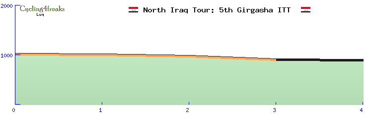 Technical Comment
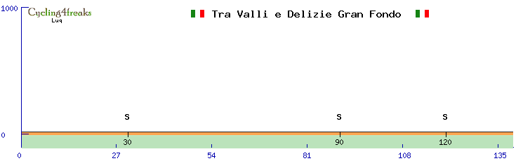
4km that can reopen the GC, or at least define positions. Riding with risk without risk? How will this downhill affect the fight for the GC? Last pavè km * can result in something strange?
Roads
Not much to see here, we start again from Girgasha and go down to Dashe Village, roads are not really paved there, there is a sort of road and sand
http://www.panoramio.com/photo/50742194 .