
Here's the long waited thread to post your tours!
One post per tour/designer. Only post tours here, discussions in the other thread.
Deadline is the end of the month.
December Tour 2025: Presentation
Moderators: systemmods, Calendarmods
-
Tukhtahuaev
- Posts: 457
- Joined: Fri May 13, 2016 7:07 pm
- Contact:
Re: December Tour 2025: Presentation
La Ruta Azteca
Tour summary:
9 riders per team
14 days, 13 stages over 2078km with a rest day after stage 7
29690m of elevation gain in total
2 Intermediate sprints on every stage except the ITT
GPM categories completely arbitrary
Stage classifications:
Flat: 4
Hilly: 4
Mountain: 4
ITT: 1
As the name already suggests, the race takes place in central Mexico around Mexico City in what was considered part of the Aztec empire (With some creative liberties taken to get more interesting stages). Big parts of the tour will take place at rather high elevation, so it might be a little bit cold at times, but it should still be warm enough to not be an issue.
Map

Stage 1: Pachuca - Saldarriaga
Flat, 206km
The tour starts in Pachuca, the capital of the state of Hidalgo. Founded by the Aztecs arround 1438 as Patlachihuacán, the city has for most of its history been an important mining center.
From Pachuca we travel north west over a small climb near Jonacapa, where we'll award the first and only mountain points of this stage. With about 100km to go and no real difficulties after that, sprinters should not be in trouble and should be the ones fighting for the stage win in Saldarriaga.

The Reloj Monumental, Icon of Pachuca
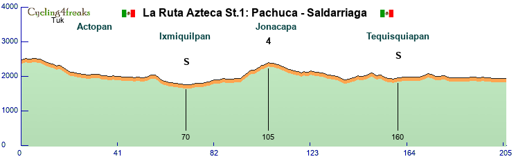
Jonacapa: 5 5 5 6 2 0 5 4 5 0 4 4
Last 5km: 0 0 0 0 0
Mintact: Km 204
Stage 2: Santiago de Querétaro - Santiago Mexquititlán
Hilly, 151km
The second day could already be a pretty important one for every rider with GC ambitions thanks to 5 sections of cobblestone roads, adding up to a total of 21km.
The stage starts in Santiago de Querétaro. In the pre-Hispanic period the region was settled by Otomí people, wo where subjects to the Aztec empire. The city itself was founded by Conín (and Juan Sánchez de Alaniz), an important figure in fighting the Aztecs after the Spanish arrived in Mexico.
The stage starts with an easy climb up to a monument honoring Conín, which is followed by an almost 50km long flat section to San Juan del Río. There we have another small hill until we finally reach the first 2 cobble sections. These are still far from the finish and with no further difficulties for a while should only serve as a warm up.
The real fun starts at km105 with the cobbled climb up to San Pablo, where climbers could be in trouble as it's not steep enough for them to compensate their lack of pavé skill. There's nto much rest after a short downhill until we have a difficult 6km long cobble section, where significant time gaps are to be expected. After another 13km of mostly flat terrain without difficulties, we reach the final cobble section, another 6km of cobbles, with the second half of it being slightly uphill and part of the second categorised climb of the day. Following the short climb, there's only 7km left until the finish in Amealco de Bonfil.

The monument honoring Conín
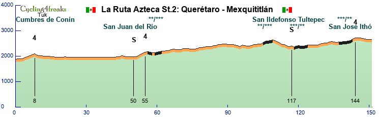
Cumbres de Conín: 5 2 5 4 3
San José Ithó: 3*** 5*** 5
Last 10km: 3*** 5*** 5 -1 0 -1 -2 -2 -1 1
Mintact: Km 104
Stage 3: Santiago Mexquititlán - Ixtlahuaca
Hilly, 159km
After a bit of GC action, stage 3 is more of a transition stage. A total of 4 categorised climbs, but none of them should create relevant GC gaps. Starting in Santiago Mexquititlán we quickly arrive to the first 2 climbs of the day, with the second one being quite steep. After that we have slightly undulating terrain and 2 more categorised climbs within 30km of the finish. This could be a good chance for strong classics or an escape to win the stage.
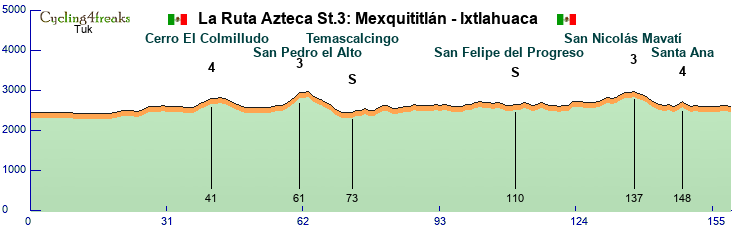
Cerro El Colmilludo: 6 6 4 6
San Pedro el Alto: 5 7 10 10
San Nicolás Mavatí: 3 6 4 -1 1 7 7 -2 4
Santa Ana: 3 8
Last 10km: -4 1 -1 -1 1 0 0 1 0 -1
Mintact: Km 134
Stage 4: Ixtlahuaca - San Mateo Tlalchichilpan
ITT, 33km
Stage 4 is again a day for the GC riders. A 33km Time Trial starting at Ixtlahuaca, where the last stage finished and finishing in San Mateo Tlalchichilpan, a small settlement close to Toluca.
The first 28km are essentially flat, before we have a short climb. It's not that steep, but it's probably still advisable to keep a bit of energy in reserve, especially with a mountain stage coming up.
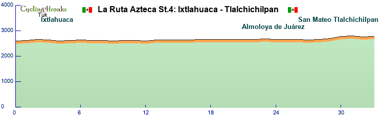
Mintact: Km 1
Stage 5: Toluca - La Glorieta
Mountain, 157km
So far climbers will have had a hard time in this tour. But from now on they will get their opportunities to claw back lost time. The region around Toluca, known as Tollocan during Aztec times, was conquered by Aztec ruler Axayacatl in 1478.
From the Toluca valley the field goes east towards the first cat 1 mountain of this tour on their way to the Centro Ceremonial Otomí, which is famous for being a filming location for the James Bond movie Licence to Kill. After a long downhill we reach another difficult climb to Pico Danxi. Desperate riders may already try long range attacks on one of these two climbs, but a long section in the valley of Mexico makes them unlikely to succeed.
Most likely it will come down to the final climbs of the day. Both Cerro de la Campana and the climb to the finish in La Glorieta are short, but quite steep.

Centro Ceremonial Otomí, used in filming for License to kill
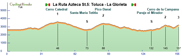
Cerro Catedral: 4 6 7 7 7 7 9 4 5 8 6 2 1 -1 3 5 5 4
Pico Danxi: 9 6 9 9 6 6 6 6 6 2 4
Cerro de la Campana: 6 10 7 7 11
Last 10km: 2 -2 -6 -5 -10 3 7 10 8 8
Mintact: Km 140
Stage 6: Tlalnepantla - Puebla
Flat, 178km
Stage 6 finally starts at the heart of the Aztec Empire. Tlalnepantla was historically a part of Mexico City, the location of the Aztec capital Tenochtitlan.
The stage itself is not exactly spectacular. Cerro Huilotepec after about 60km is the only difficulty and sprinters should not have too much trouble. The finish is located in Puebla, the fouth largest city of Mexico.

The city of Tenochtitlan. Unfortunately not much of it remains in modern times
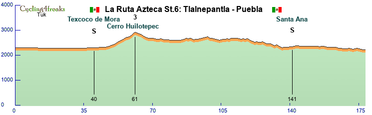
Cerro Huilotepec: 3 3 3 4 6 4 3 5 5 2 3 6 5 6
Last 5 km: 3 -2 -2 -3 1
Mintact: Km 174
Stage 7: Atlixco - Cuernavaca
Mountain, 171km
The final stage before the rest day starts in Atlixco, known as Acapetlahuacan during Aztec rule. In 1521 residents of Atlixco conspired with the Spanish to stop being tributaries of the Aztecs and helped in the siege of Tenochtitlan.
The stage itself should be pretty relaxed for the first 120km, with only two cat 4 climbs as a warm up. After 120km we reach the finish city of Cuernavaca for the first time. From there the riders have to climb one of the most difficult climbs of this tour, the first HC climb up to Tres Marías. Especially the final part with several kms over 11% gradient is a difficult challenge. The following 27km of descent could neutralise gaps a bit, but some time gaps or long range moves are certainly possible.

The temple of Teopanzolco was built in Cuernavaca during Aztec times
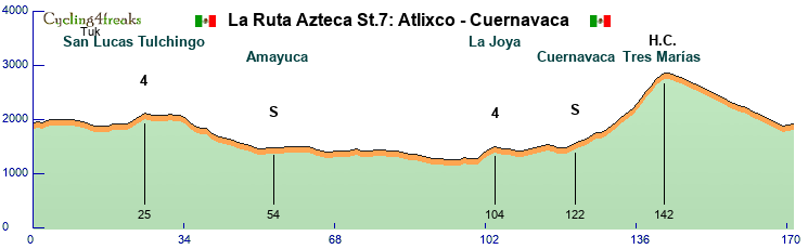
San Lucas Tulchingo: 4 5 5 6
La Joya: 7 6 4 5
Tres Marías: 6 6 7 7 7 6 6 9 11 11 11 11 6 7
Last 5km: -4 -5 -3 2 2
Mintact: Km 126
Rest Day
Stage 8: Xicotepec de Juárez - Martínez de la Torre
Flat, 179km
After the rest day sprinters should get their 3rd chance for a stage win. We are starting over 1000m above sea level in Xicotepec de Juárez, but the majority of the stage takes place at less than 100m above sea level.
It is not without difficulties though, as the riders immediately have to climb a short hill at the start. Following a long downhill, the stage is mostly flat, but there's a few short hills scattered around the stage. With only 6km at 6% elevation or above and the last of them being over 40km away from the finish, sprinters should still be able to easily control the stage.
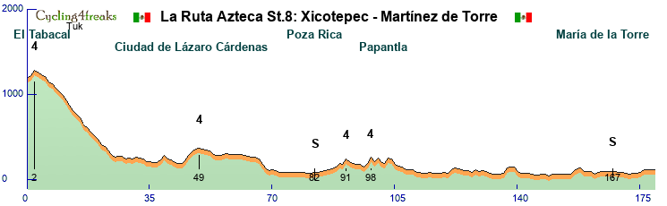
El Tabacal: 3 6
Ciudad de Lázaro Cárdenas: 3 6 4 3 2
3rd cat 4: 5 -1 6
Papantla: 4 7
Last 5km: 1 3 0 0 0
Mintact: Km 176
Stage 9: Martínez de la Torre - Xalapa
Hilly, 158km
After a day in the lowlands, the riders will immediately get up to higher altitudes. After about 35km of flat terrain, the riders have to climb up almost 2000m to Chiconquiaco. It's a very long climb, but only small sections of it are really challenging. Following a long downhill, the riders have to challenge two additional categorised climbs, which are much shorter, but not less difficult. After that we reach our destination in Xalapa, but the riders are not finished yet as there is a short detour with another short, but steep climb just before the finish.

The stage finished right besides the Museo de Antropología de Xalapa, where you can see interesting Mesoamerican sculptures like this
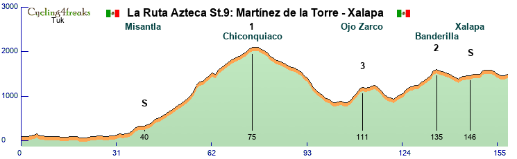
Chiconquiaco: 5 6 5 -1 1 2 4 6 4 2 5 5 4 4 6 4 4 6 6 6 11 13 7 2 5 6 7 -3 9 4 7 4 6 4 4 2 5 5 6 4
Ojo Zarco: 7 7 7 10 4
Banderilla: 4 6 3 7 7 1 3 0 6 5 5 6 10 3
Last 10km: 0 8 1 0 0 -4 -6 -2 0 2
Mintact: Km 122
Stage 10: Xalapa - Cuitláhuac
Flat, 198km
Stage 10 will probably be the final opportunity for sprinters to get a stagewin. There are no relevant difficulties at all as riders riders will make their way from Xalapa down towards the Gulf of Mexico around Veracruz. From there riders go west on a very long section of slight uphill, never going above 2% gradient towards the finish in Cuitláhuac, which is named after the Aztec emperor who died during the siege of Tenochtitlan.
Cuitláhuac died after ruling just 80 days, most likely from smallpox
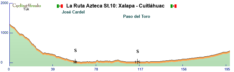
Last 5km: 0 0 1 1 2
Mintact: Km 196
Stage 11: Córdoba - Xometla
Mountain, 187km
After a slow start to week 2, now it is time for the the GC captains to shine as they are faced with two difficult mountain stages in a row. Today we have 5 categorised climbs, two of them cat 1 and also a HC climb.
After about 20km the riders will have their first warm up with a 4km climb, but the real deal starts only after about 60km with the Cumbres de Aquila climb with an average gradient of 9.1% over 8km. Following that we have long flat section and downhill before finally reaching the hardest climb of the day up to Chicahuaxtla. 12km long and about 9% average gradient make this the perfect opportunity for early attacks. The next 35km barely have any flat sections with another short cat 3 climb and a downhill before riders face the final climb of the day towards Xometla. This one is not quite as steep, but 14km at 7.4% gradient are still a big challenge.
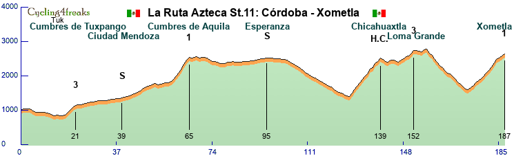
Cumbres de Tuxpango: 8 8 7 6
Cumbres de Aquila: 4 6 9 11 12 12 12 7
Chicahuaxtla: 10 10 10 11 9 8 9 13 5 12 6 9
Loma Grande: 6 5 5 2 9 8
Xometla: 5 7 7 7 6 7 8 9 10 11 10 5 6 6
Mintact: Km 128
Stage 12: Orizaba - Mexcala
Mountain, 124km
After a long day yesterday, this one will be quite a bit shorter, but not less difficult. Again 5 categorised climbs and almost no flat sections in between will make this a tough day for everyone involved.
The first climb starts after only 8km and from there on it is almost exclusively up or down. Controlling the stage will not be easy and there should be plenty of opportunities to attack.
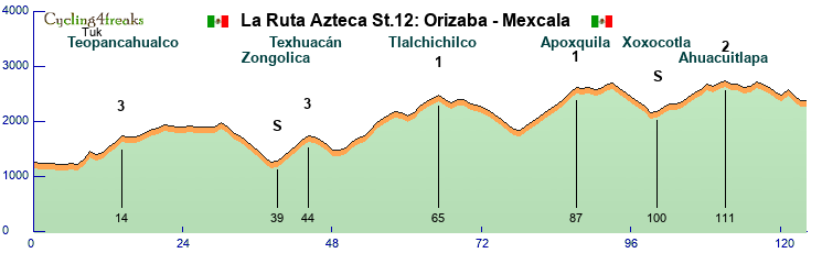
Teopancahualco: 9 14 -5 4 9 9 11
Texhuacán: 7 10 10 11 8
Tlalchichilco: 4 10 8 4 11 13 9 6 6 -3 -5 5 12 9 5 7
Apoxquila: 7 8 9 8 8 7 9 11 10
Ahuacuitlapa: 3 8 5 1 3 9 8 6 9 -3 5 5
Last 10km: 2 8 -3 -6 -8 -6 10 -11 -9 0
Mintact: Km 78
Stage 13: Puente de Guadalupe - Tehuacán
Hilly, 177km
After two grueling days in the mountains the final day could almost be described as relaxing. But there are still some opportunities to create gaps.
Riders will immediately have to tackle the Cumbres de Acultzingo, the most difficult climb of the day. The last 6km of this one average almost 6% gradient. After this it gets a lot easier though with none of the three remaining climbs being particularly difficult. The climb towards Nicolás Bravo could look intimidating at first glance, but it's not steep enough to put any GC rider in trouble. The final difficulty of this tour is a climb just before the finish in Tehuacán.

Tehuacán is nicknamed the Place of Gods. The cathedral of Tehuacán is the headquarters of the catholic Diocese of the region.
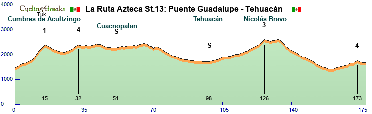
Cumbres de Acultzingo: 4 4 5 10 12 12 9 8 7
1st cat 4: 3 3 4 4 5 6 5
Nicolás Bravo: 3 3 3 3 4 5 5 3 4 5 6 8 7
2nd cat 4: 6 2 1 5 4
Last 10km: 2 6 2 1 5 4 -4 -2 -1 0
Mintact: Km 168
Tour summary:
9 riders per team
14 days, 13 stages over 2078km with a rest day after stage 7
29690m of elevation gain in total
2 Intermediate sprints on every stage except the ITT
GPM categories completely arbitrary
Stage classifications:
Flat: 4
Hilly: 4
Mountain: 4
ITT: 1
As the name already suggests, the race takes place in central Mexico around Mexico City in what was considered part of the Aztec empire (With some creative liberties taken to get more interesting stages). Big parts of the tour will take place at rather high elevation, so it might be a little bit cold at times, but it should still be warm enough to not be an issue.
Map
Stage 1: Pachuca - Saldarriaga
Flat, 206km
The tour starts in Pachuca, the capital of the state of Hidalgo. Founded by the Aztecs arround 1438 as Patlachihuacán, the city has for most of its history been an important mining center.
From Pachuca we travel north west over a small climb near Jonacapa, where we'll award the first and only mountain points of this stage. With about 100km to go and no real difficulties after that, sprinters should not be in trouble and should be the ones fighting for the stage win in Saldarriaga.
The Reloj Monumental, Icon of Pachuca
Jonacapa: 5 5 5 6 2 0 5 4 5 0 4 4
Last 5km: 0 0 0 0 0
Mintact: Km 204
Stage 2: Santiago de Querétaro - Santiago Mexquititlán
Hilly, 151km
The second day could already be a pretty important one for every rider with GC ambitions thanks to 5 sections of cobblestone roads, adding up to a total of 21km.
The stage starts in Santiago de Querétaro. In the pre-Hispanic period the region was settled by Otomí people, wo where subjects to the Aztec empire. The city itself was founded by Conín (and Juan Sánchez de Alaniz), an important figure in fighting the Aztecs after the Spanish arrived in Mexico.
The stage starts with an easy climb up to a monument honoring Conín, which is followed by an almost 50km long flat section to San Juan del Río. There we have another small hill until we finally reach the first 2 cobble sections. These are still far from the finish and with no further difficulties for a while should only serve as a warm up.
The real fun starts at km105 with the cobbled climb up to San Pablo, where climbers could be in trouble as it's not steep enough for them to compensate their lack of pavé skill. There's nto much rest after a short downhill until we have a difficult 6km long cobble section, where significant time gaps are to be expected. After another 13km of mostly flat terrain without difficulties, we reach the final cobble section, another 6km of cobbles, with the second half of it being slightly uphill and part of the second categorised climb of the day. Following the short climb, there's only 7km left until the finish in Amealco de Bonfil.
The monument honoring Conín
Cumbres de Conín: 5 2 5 4 3
San José Ithó: 3*** 5*** 5
Last 10km: 3*** 5*** 5 -1 0 -1 -2 -2 -1 1
Mintact: Km 104
Stage 3: Santiago Mexquititlán - Ixtlahuaca
Hilly, 159km
After a bit of GC action, stage 3 is more of a transition stage. A total of 4 categorised climbs, but none of them should create relevant GC gaps. Starting in Santiago Mexquititlán we quickly arrive to the first 2 climbs of the day, with the second one being quite steep. After that we have slightly undulating terrain and 2 more categorised climbs within 30km of the finish. This could be a good chance for strong classics or an escape to win the stage.
Cerro El Colmilludo: 6 6 4 6
San Pedro el Alto: 5 7 10 10
San Nicolás Mavatí: 3 6 4 -1 1 7 7 -2 4
Santa Ana: 3 8
Last 10km: -4 1 -1 -1 1 0 0 1 0 -1
Mintact: Km 134
Stage 4: Ixtlahuaca - San Mateo Tlalchichilpan
ITT, 33km
Stage 4 is again a day for the GC riders. A 33km Time Trial starting at Ixtlahuaca, where the last stage finished and finishing in San Mateo Tlalchichilpan, a small settlement close to Toluca.
The first 28km are essentially flat, before we have a short climb. It's not that steep, but it's probably still advisable to keep a bit of energy in reserve, especially with a mountain stage coming up.
Mintact: Km 1
Stage 5: Toluca - La Glorieta
Mountain, 157km
So far climbers will have had a hard time in this tour. But from now on they will get their opportunities to claw back lost time. The region around Toluca, known as Tollocan during Aztec times, was conquered by Aztec ruler Axayacatl in 1478.
From the Toluca valley the field goes east towards the first cat 1 mountain of this tour on their way to the Centro Ceremonial Otomí, which is famous for being a filming location for the James Bond movie Licence to Kill. After a long downhill we reach another difficult climb to Pico Danxi. Desperate riders may already try long range attacks on one of these two climbs, but a long section in the valley of Mexico makes them unlikely to succeed.
Most likely it will come down to the final climbs of the day. Both Cerro de la Campana and the climb to the finish in La Glorieta are short, but quite steep.
Centro Ceremonial Otomí, used in filming for License to kill
Cerro Catedral: 4 6 7 7 7 7 9 4 5 8 6 2 1 -1 3 5 5 4
Pico Danxi: 9 6 9 9 6 6 6 6 6 2 4
Cerro de la Campana: 6 10 7 7 11
Last 10km: 2 -2 -6 -5 -10 3 7 10 8 8
Mintact: Km 140
Stage 6: Tlalnepantla - Puebla
Flat, 178km
Stage 6 finally starts at the heart of the Aztec Empire. Tlalnepantla was historically a part of Mexico City, the location of the Aztec capital Tenochtitlan.
The stage itself is not exactly spectacular. Cerro Huilotepec after about 60km is the only difficulty and sprinters should not have too much trouble. The finish is located in Puebla, the fouth largest city of Mexico.
The city of Tenochtitlan. Unfortunately not much of it remains in modern times
Cerro Huilotepec: 3 3 3 4 6 4 3 5 5 2 3 6 5 6
Last 5 km: 3 -2 -2 -3 1
Mintact: Km 174
Stage 7: Atlixco - Cuernavaca
Mountain, 171km
The final stage before the rest day starts in Atlixco, known as Acapetlahuacan during Aztec rule. In 1521 residents of Atlixco conspired with the Spanish to stop being tributaries of the Aztecs and helped in the siege of Tenochtitlan.
The stage itself should be pretty relaxed for the first 120km, with only two cat 4 climbs as a warm up. After 120km we reach the finish city of Cuernavaca for the first time. From there the riders have to climb one of the most difficult climbs of this tour, the first HC climb up to Tres Marías. Especially the final part with several kms over 11% gradient is a difficult challenge. The following 27km of descent could neutralise gaps a bit, but some time gaps or long range moves are certainly possible.
The temple of Teopanzolco was built in Cuernavaca during Aztec times
San Lucas Tulchingo: 4 5 5 6
La Joya: 7 6 4 5
Tres Marías: 6 6 7 7 7 6 6 9 11 11 11 11 6 7
Last 5km: -4 -5 -3 2 2
Mintact: Km 126
Rest Day
Stage 8: Xicotepec de Juárez - Martínez de la Torre
Flat, 179km
After the rest day sprinters should get their 3rd chance for a stage win. We are starting over 1000m above sea level in Xicotepec de Juárez, but the majority of the stage takes place at less than 100m above sea level.
It is not without difficulties though, as the riders immediately have to climb a short hill at the start. Following a long downhill, the stage is mostly flat, but there's a few short hills scattered around the stage. With only 6km at 6% elevation or above and the last of them being over 40km away from the finish, sprinters should still be able to easily control the stage.
El Tabacal: 3 6
Ciudad de Lázaro Cárdenas: 3 6 4 3 2
3rd cat 4: 5 -1 6
Papantla: 4 7
Last 5km: 1 3 0 0 0
Mintact: Km 176
Stage 9: Martínez de la Torre - Xalapa
Hilly, 158km
After a day in the lowlands, the riders will immediately get up to higher altitudes. After about 35km of flat terrain, the riders have to climb up almost 2000m to Chiconquiaco. It's a very long climb, but only small sections of it are really challenging. Following a long downhill, the riders have to challenge two additional categorised climbs, which are much shorter, but not less difficult. After that we reach our destination in Xalapa, but the riders are not finished yet as there is a short detour with another short, but steep climb just before the finish.
The stage finished right besides the Museo de Antropología de Xalapa, where you can see interesting Mesoamerican sculptures like this
Chiconquiaco: 5 6 5 -1 1 2 4 6 4 2 5 5 4 4 6 4 4 6 6 6 11 13 7 2 5 6 7 -3 9 4 7 4 6 4 4 2 5 5 6 4
Ojo Zarco: 7 7 7 10 4
Banderilla: 4 6 3 7 7 1 3 0 6 5 5 6 10 3
Last 10km: 0 8 1 0 0 -4 -6 -2 0 2
Mintact: Km 122
Stage 10: Xalapa - Cuitláhuac
Flat, 198km
Stage 10 will probably be the final opportunity for sprinters to get a stagewin. There are no relevant difficulties at all as riders riders will make their way from Xalapa down towards the Gulf of Mexico around Veracruz. From there riders go west on a very long section of slight uphill, never going above 2% gradient towards the finish in Cuitláhuac, which is named after the Aztec emperor who died during the siege of Tenochtitlan.
Cuitláhuac died after ruling just 80 days, most likely from smallpox
Last 5km: 0 0 1 1 2
Mintact: Km 196
Stage 11: Córdoba - Xometla
Mountain, 187km
After a slow start to week 2, now it is time for the the GC captains to shine as they are faced with two difficult mountain stages in a row. Today we have 5 categorised climbs, two of them cat 1 and also a HC climb.
After about 20km the riders will have their first warm up with a 4km climb, but the real deal starts only after about 60km with the Cumbres de Aquila climb with an average gradient of 9.1% over 8km. Following that we have long flat section and downhill before finally reaching the hardest climb of the day up to Chicahuaxtla. 12km long and about 9% average gradient make this the perfect opportunity for early attacks. The next 35km barely have any flat sections with another short cat 3 climb and a downhill before riders face the final climb of the day towards Xometla. This one is not quite as steep, but 14km at 7.4% gradient are still a big challenge.
Cumbres de Tuxpango: 8 8 7 6
Cumbres de Aquila: 4 6 9 11 12 12 12 7
Chicahuaxtla: 10 10 10 11 9 8 9 13 5 12 6 9
Loma Grande: 6 5 5 2 9 8
Xometla: 5 7 7 7 6 7 8 9 10 11 10 5 6 6
Mintact: Km 128
Stage 12: Orizaba - Mexcala
Mountain, 124km
After a long day yesterday, this one will be quite a bit shorter, but not less difficult. Again 5 categorised climbs and almost no flat sections in between will make this a tough day for everyone involved.
The first climb starts after only 8km and from there on it is almost exclusively up or down. Controlling the stage will not be easy and there should be plenty of opportunities to attack.
Teopancahualco: 9 14 -5 4 9 9 11
Texhuacán: 7 10 10 11 8
Tlalchichilco: 4 10 8 4 11 13 9 6 6 -3 -5 5 12 9 5 7
Apoxquila: 7 8 9 8 8 7 9 11 10
Ahuacuitlapa: 3 8 5 1 3 9 8 6 9 -3 5 5
Last 10km: 2 8 -3 -6 -8 -6 10 -11 -9 0
Mintact: Km 78
Stage 13: Puente de Guadalupe - Tehuacán
Hilly, 177km
After two grueling days in the mountains the final day could almost be described as relaxing. But there are still some opportunities to create gaps.
Riders will immediately have to tackle the Cumbres de Acultzingo, the most difficult climb of the day. The last 6km of this one average almost 6% gradient. After this it gets a lot easier though with none of the three remaining climbs being particularly difficult. The climb towards Nicolás Bravo could look intimidating at first glance, but it's not steep enough to put any GC rider in trouble. The final difficulty of this tour is a climb just before the finish in Tehuacán.
Tehuacán is nicknamed the Place of Gods. The cathedral of Tehuacán is the headquarters of the catholic Diocese of the region.
Cumbres de Acultzingo: 4 4 5 10 12 12 9 8 7
1st cat 4: 3 3 4 4 5 6 5
Nicolás Bravo: 3 3 3 3 4 5 5 3 4 5 6 8 7
2nd cat 4: 6 2 1 5 4
Last 10km: 2 6 2 1 5 4 -4 -2 -1 0
Mintact: Km 168
Last edited by Tukhtahuaev on Mon Oct 06, 2025 2:43 pm, edited 1 time in total.
-
TDM_Luxembourg
- Posts: 122
- Joined: Thu Feb 20, 2025 6:06 pm
- Contact:
Re: December Tour 2025: Presentation
Not sure how legal my presentation is, I hope it works like that, because it was a lot of work :p
LA VOLTA DE TIQUICIA
LA VOLTA DE TIQUICIA
-
Hoefs Cycling Team
- Posts: 106
- Joined: Tue Apr 08, 2025 10:13 am
- Contact:
Re: December Tour 2025: Presentation
Vegas Tour

Tour summary:
8 riders per team.
10 stages total: 1456 kilometres and 14470 elevation meters.
3 Intermediate sprints and nice mountains/hills on every stage: Min Tact on last 10 km (except the ITT's).
Stage classifications:
Flat: 4
Hilly: 2
Mountain: 2
ITT: 2
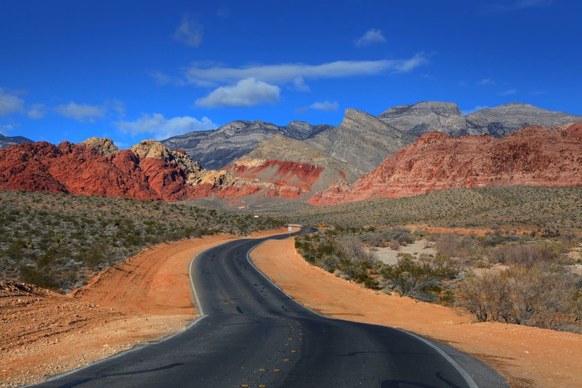
We are going to Vegas baby!
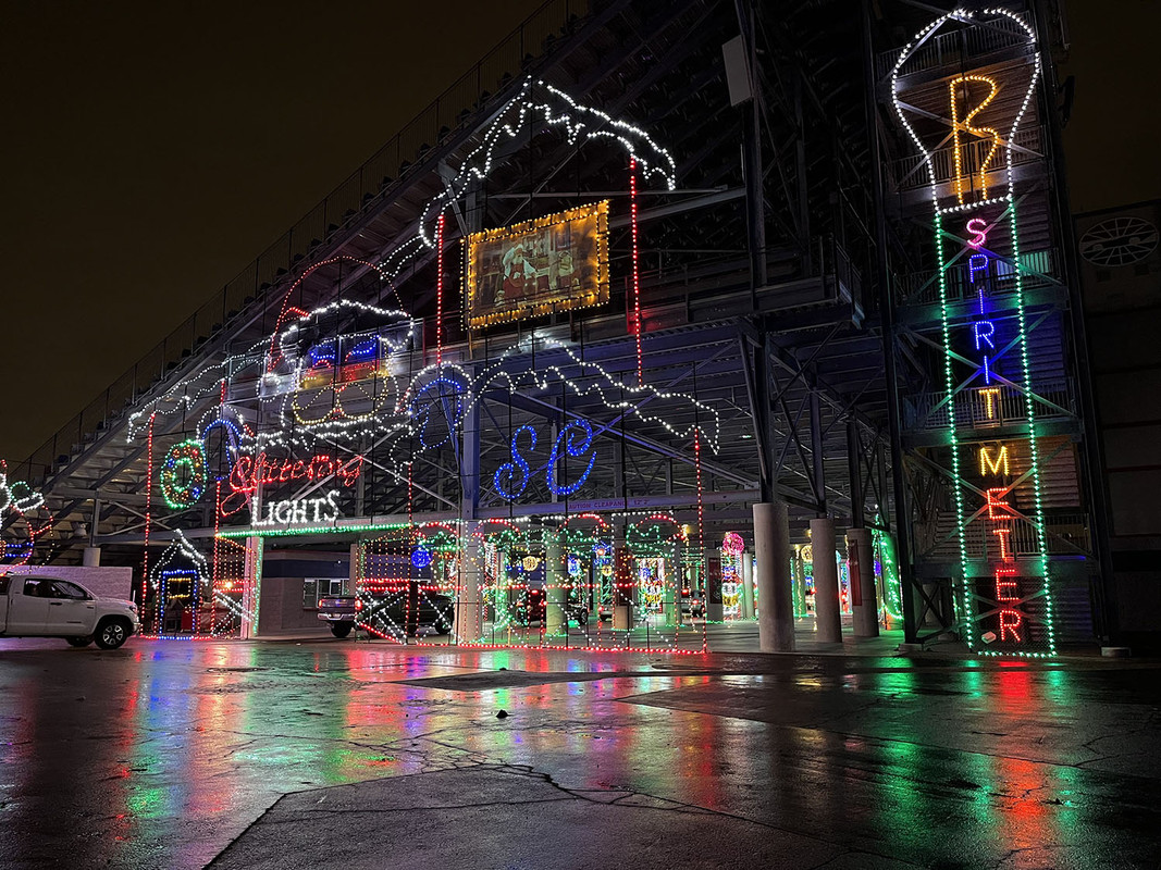
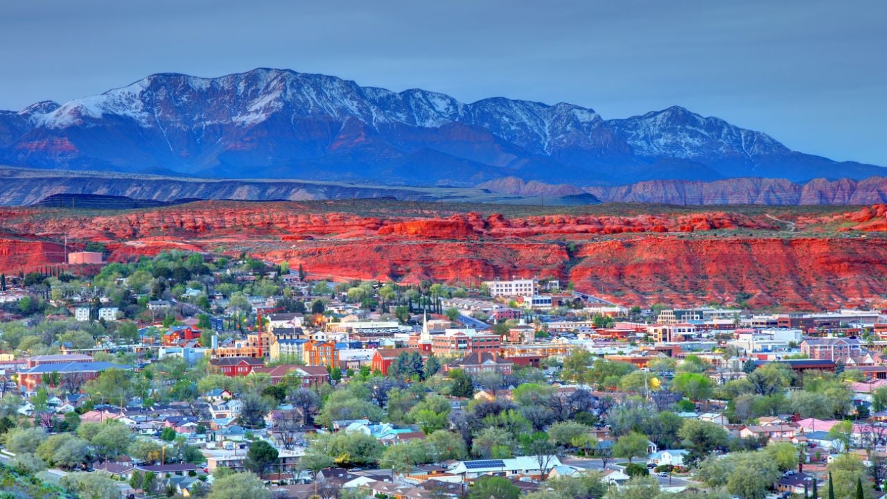
A ten day tour in and around the entertainment capital of the world! Glitter, glamour and a lot of gamble! But most important it's breathes Christmas!
Map
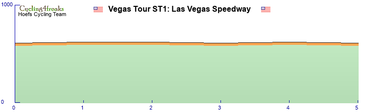
Stage 1: which TTer dares to take some risk?
A short ITT of 5 km on the Speedway of Las Vegas.
A track in Christmas lights.
Stage 2: first chance of MS
A flat stage with 3 hills in and around Las Vegas.
Dessert Hill Cat4: 4% 6%
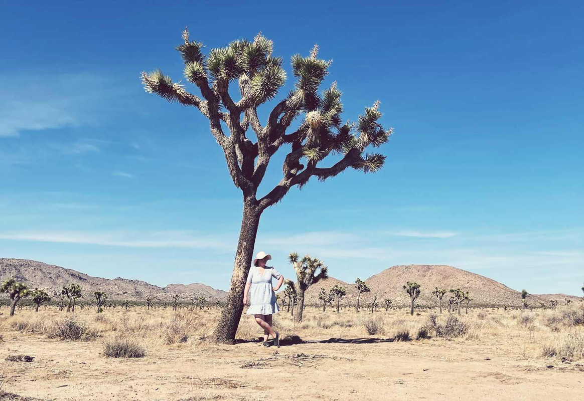
Joshua Tree Hill Cat4: long climb max 4%
Crescent Peak Cat2: 8% 5% 7%
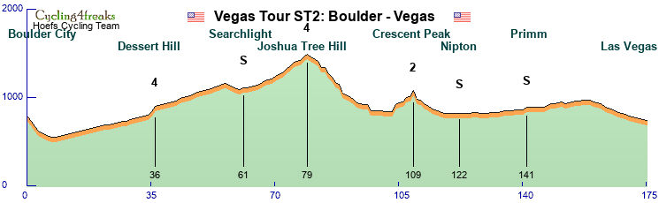
Stage 3: second chance of MS
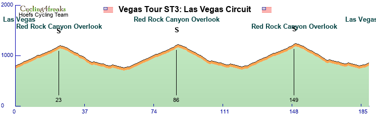
Las Vegas "Circuit" 3 rounds in Las Vegas: flat with a Christmas colored hill.
Stage 4: a mountain guy in lead
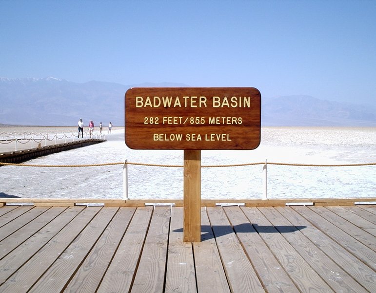
Death Valley National Park. A mountain stage to the hottest place on earth: Badwater, with a finish on a big mountain top.
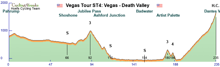
Jubilee Pass Cat3: 5% 7% 5% 6%
Artist Palette Cat3: 7% 8% 9% 6%
Artist Palette Cat4: 7% 4%
Dantes V(iew) H.C.: Very long climb 3-5% in beginning, last 9 km 5-11%
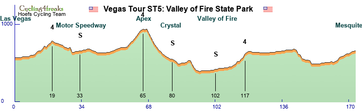
Stage 5: third chance of MS
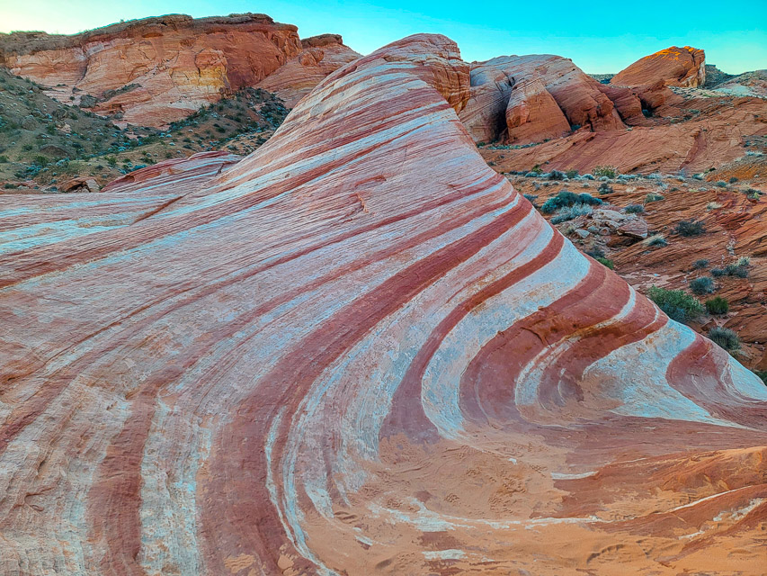
Valley of Fire State Park. A "flatt" race in beautiful surroundings.
Stage 6: a stage for the classics
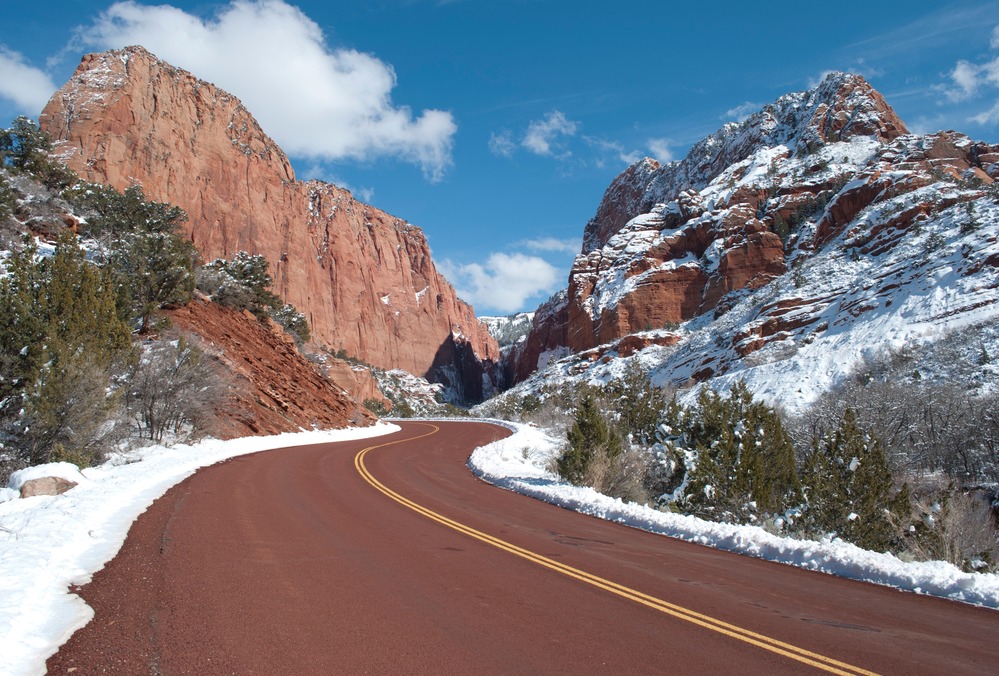
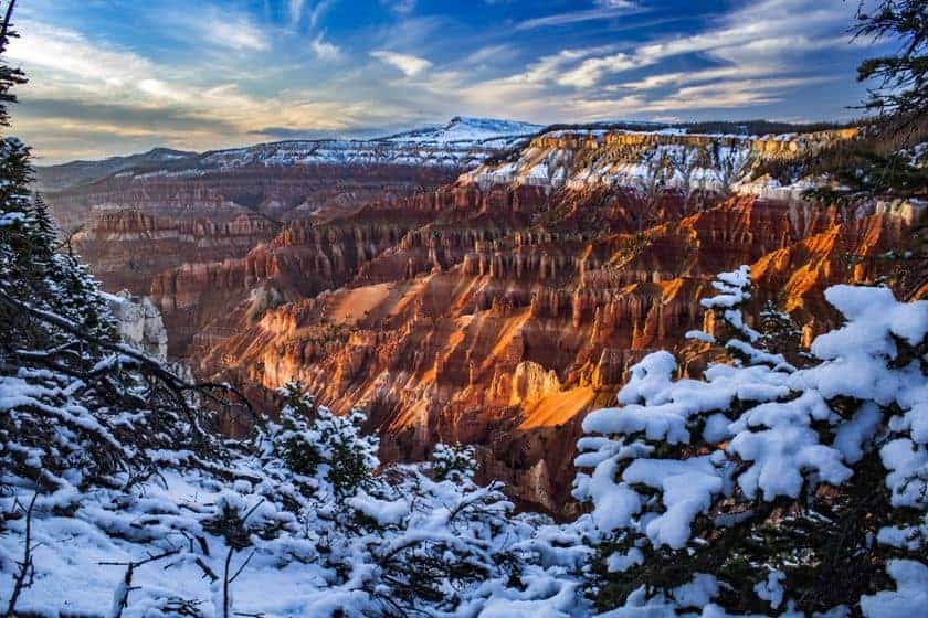
Zion National Park. A hilly stage, uphill finish at the Kolob Canyon: Christmas Winterwonderland.
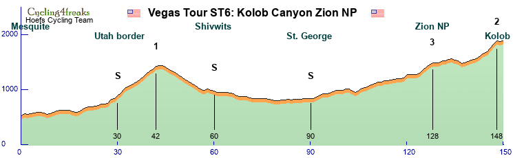
Utah border Cat1: 7% 5% 5% 8% in beginning, 6 km a 5% in the end
Zion NP Cat 3: 6% 6% 5%
Kolob Cat 2: 5% 8% 6% 6% -1% 2%
Stage 7: a second stage for the mountain guys
Cedar Breaks National Monument. A mountain stage with finish on Coal Hill.
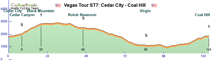
Black Mountain Cat 1: 10 km 5-10%
Coal Hill Cat1: 9 km 6-9%
Stage 8: tricky race for a cobble guy who is strong on hills
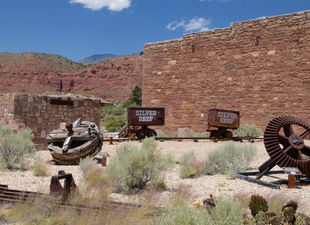
Silver Reef Ghost Town. A hilly race to a Western Ghost Town, with a lot of cobbles at the end.
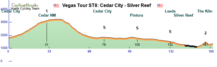
Cedar NM Cat 1: 12 km 5-9%
Cobble section, 10 km long: 3 km * , 6 km ** , 1 km ***
The Kiln Cat 2: 6 km 4-10%
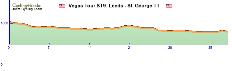
Stage 9: the best TTer will win
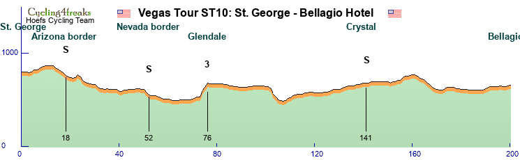
A middle long ITT to the beautiful St.George.
Stage 10: fourth chance of MS
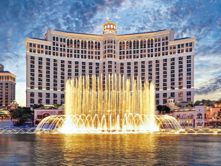
Last stage finishing on the Strip at the Bellagio Hotel in Christmas sphere


Vegas Tour: time for a gamble!
Tour summary:
8 riders per team.
10 stages total: 1456 kilometres and 14470 elevation meters.
3 Intermediate sprints and nice mountains/hills on every stage: Min Tact on last 10 km (except the ITT's).
Stage classifications:
Flat: 4
Hilly: 2
Mountain: 2
ITT: 2
We are going to Vegas baby!
A ten day tour in and around the entertainment capital of the world! Glitter, glamour and a lot of gamble! But most important it's breathes Christmas!
Map
Stage 1: which TTer dares to take some risk?
A short ITT of 5 km on the Speedway of Las Vegas.
A track in Christmas lights.
Stage 2: first chance of MS
A flat stage with 3 hills in and around Las Vegas.
Dessert Hill Cat4: 4% 6%
Joshua Tree Hill Cat4: long climb max 4%
Crescent Peak Cat2: 8% 5% 7%
Stage 3: second chance of MS
Las Vegas "Circuit" 3 rounds in Las Vegas: flat with a Christmas colored hill.
Stage 4: a mountain guy in lead
Death Valley National Park. A mountain stage to the hottest place on earth: Badwater, with a finish on a big mountain top.
Jubilee Pass Cat3: 5% 7% 5% 6%
Artist Palette Cat3: 7% 8% 9% 6%
Artist Palette Cat4: 7% 4%
Dantes V(iew) H.C.: Very long climb 3-5% in beginning, last 9 km 5-11%
Stage 5: third chance of MS
Valley of Fire State Park. A "flatt" race in beautiful surroundings.
Stage 6: a stage for the classics
Zion National Park. A hilly stage, uphill finish at the Kolob Canyon: Christmas Winterwonderland.
Utah border Cat1: 7% 5% 5% 8% in beginning, 6 km a 5% in the end
Zion NP Cat 3: 6% 6% 5%
Kolob Cat 2: 5% 8% 6% 6% -1% 2%
Stage 7: a second stage for the mountain guys
Cedar Breaks National Monument. A mountain stage with finish on Coal Hill.
Black Mountain Cat 1: 10 km 5-10%
Coal Hill Cat1: 9 km 6-9%
Stage 8: tricky race for a cobble guy who is strong on hills
Silver Reef Ghost Town. A hilly race to a Western Ghost Town, with a lot of cobbles at the end.
Cedar NM Cat 1: 12 km 5-9%
Cobble section, 10 km long: 3 km * , 6 km ** , 1 km ***
The Kiln Cat 2: 6 km 4-10%
Stage 9: the best TTer will win
A middle long ITT to the beautiful St.George.
Stage 10: fourth chance of MS
Last stage finishing on the Strip at the Bellagio Hotel in Christmas sphere
Vegas Tour: time for a gamble!
Re: December Tour 2025: Presentation
Australian East Coast Tour 2025
Introduction
Working where others go to holidays - Thats a dream that could come true for all cyclists if their managers vote for the "Australian East Coast Tour 2025". The tour is more or less divided into 2 parts. While the first 6 stages will take part in the state of Queensland in the territory between Gold- and Sunshine Coast around Brisbane, where the tour starts, the riders will be transferred to the state of New South Wales on the restday. From there on the next 7 Stages lead them south passing the capital Canberra and finally entering the state of Victoria where the tour will end in Melbourne.
Due to the very special geographics alongst Australian East Coast riders will find a variety of possibilities to show their strengths. While the real big mountains are lacking the organizing team found a huge amount of interesting roads that guarantee for races the riders will never forget (if in the good or bad way lies alone in their hands and the hands of their managers). This will feature some very tricky short climbs, some paved roads and some other surprises you can take from the roadbook.
General Information
9 riders per team
13 Stages + 1 Rest Day in total split into:
6 Flat Stages
5 Middle Mountain Stages
2 H.C. Mountain Stages
2.163 km in total
166 km per stage
24.000 hm in total
1.846 hm per stage
94 min average riding time
Stage presentation will be the following:
Stage Number – Stage start to stage finish – Stage Type – Stage length – Stage ascent – Mintact at km: xxx – Stage duration: xxx min
Rules for IS and GPM:
2 intermediate sprints per stage valued with 6-4-2 points for the first 3 riders and 3,2,1 seconds
The GPM will be categorized and presented as follows:
Cat. 4 - >200hm or presenters choice - Name - KM - Length - HM - average steepness - Steepest km
Cat. 3 - >400hm or over 250hm and 5% - Name - KM - Length - HM - average steepness - Steepest km
Cat. 2 - >600hm or over 400hm and 5% - Name - KM - Length - HM - average steepness - Complete Climb profile and steepest KM
Cat. 1 - >800hm or over 500hm and 5% - Name - KM - Length - HM - average steepness - Complete Climb profile and steepest KM
HC - >1000hm or over 800hm and 6% - Name - KM - Length - HM - average steepness - Complete Climb profile and steepest KM
If a climb has special characteristics but does not fit certain criteria its up to the designer to choose another category. This decision might also include the position of the climb in the race.
The pave sections will be categorized and presented as follows:
* = Usual dry gravel
** = Unpaved possibly wet sections / "easy hiking trail"
*** = Unpaved and wet sections / "hiking trail"
All km, all %, All *
Rules for stage finishes:
Points according to the usual C4F regulations
10,6,4 second on all stages except ITT in the finish!
Stage 1 – Brisbane to Toowoomba – Flat Stage - 179 km – 1.730 hm – Mintact at KM: 160 – Stage duration: 99 min
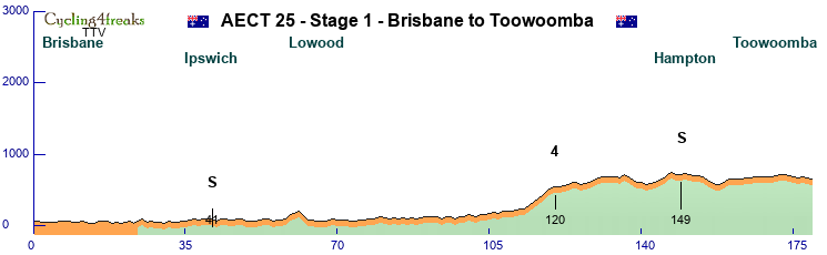


^ Brisbane ^
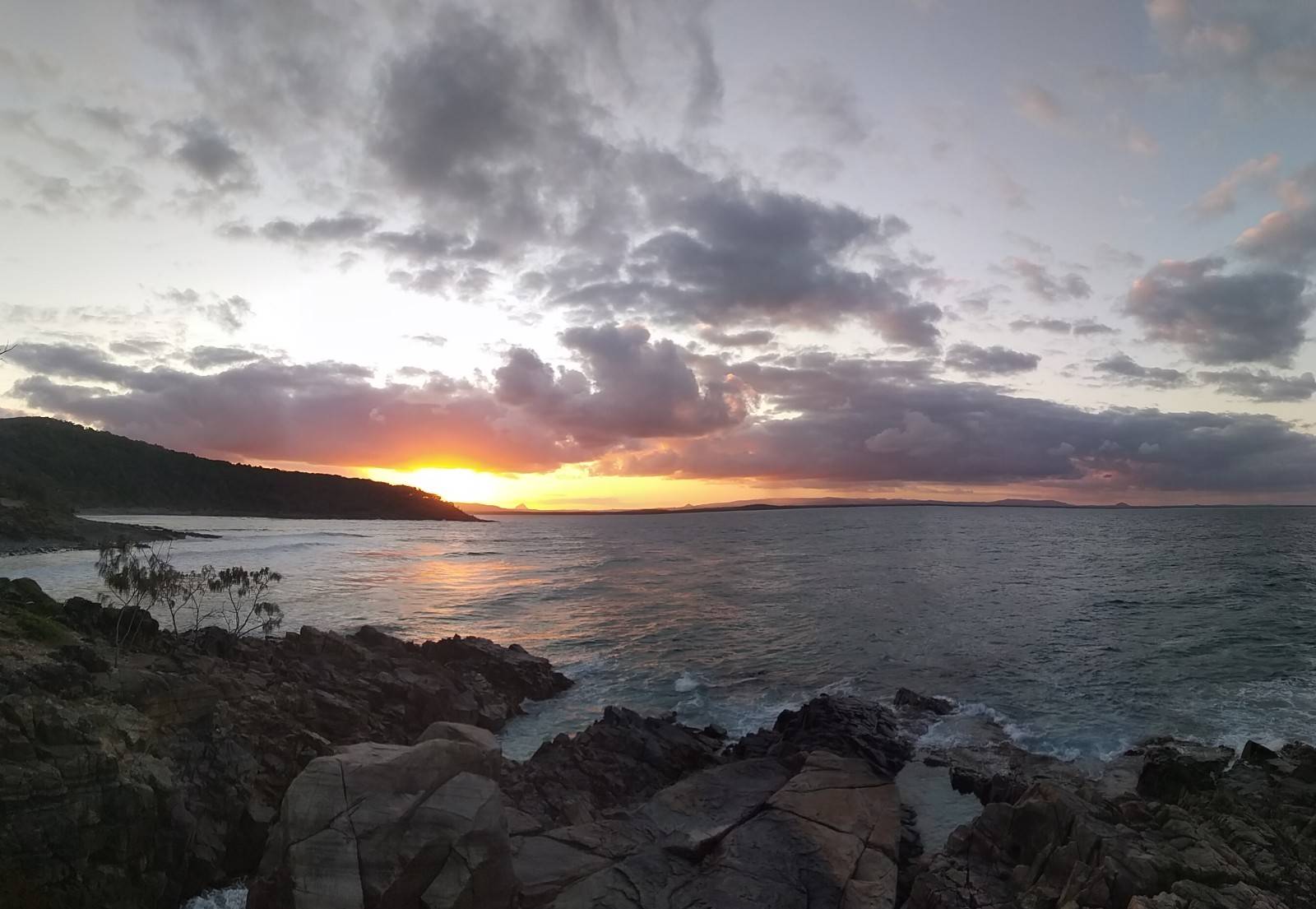
Brisbane which will host the 2032 summer olympics is a 2 million inhabitants city on the Australian East Coast. After the start at Roma Street parklands the first part of the route will follow Brisbane river east but cutting its flaws to make the route a little shorter. This will continue for the first 40km until the town of Ipswich where the first sprint of the tour takes part.
From there the route swaps into northern direction passing Lowood where after nearly 60km the first sieb km of the tour is in (7). The route continues flat alongside the shores of Lake Wivenhoe, which is used as a power plant for Brisbane using the waters of Brisbane river.
^ Lake Wivenhoe ^
After leaving Lake Wivenhoe at its north end the route starts to climb a little between Esk and Hampton where the first mountain points of this tour will be given. In addition even if a long way from the finish maybe a team or two will for the first time test the sprinter teams.
The following 40km are pretty flat including a sprint in Hampton (KM 149), but also 2 times a 5 at 136 and at 160 as last siebing chance, and a 3,5% 4km climb up to Hampton. So normally on the last 20km the sprinter teams should be able to keep their things together but nothing is sure except that the finish is in Toowoomba which due to its many parks and green spots is also called "Garden City"
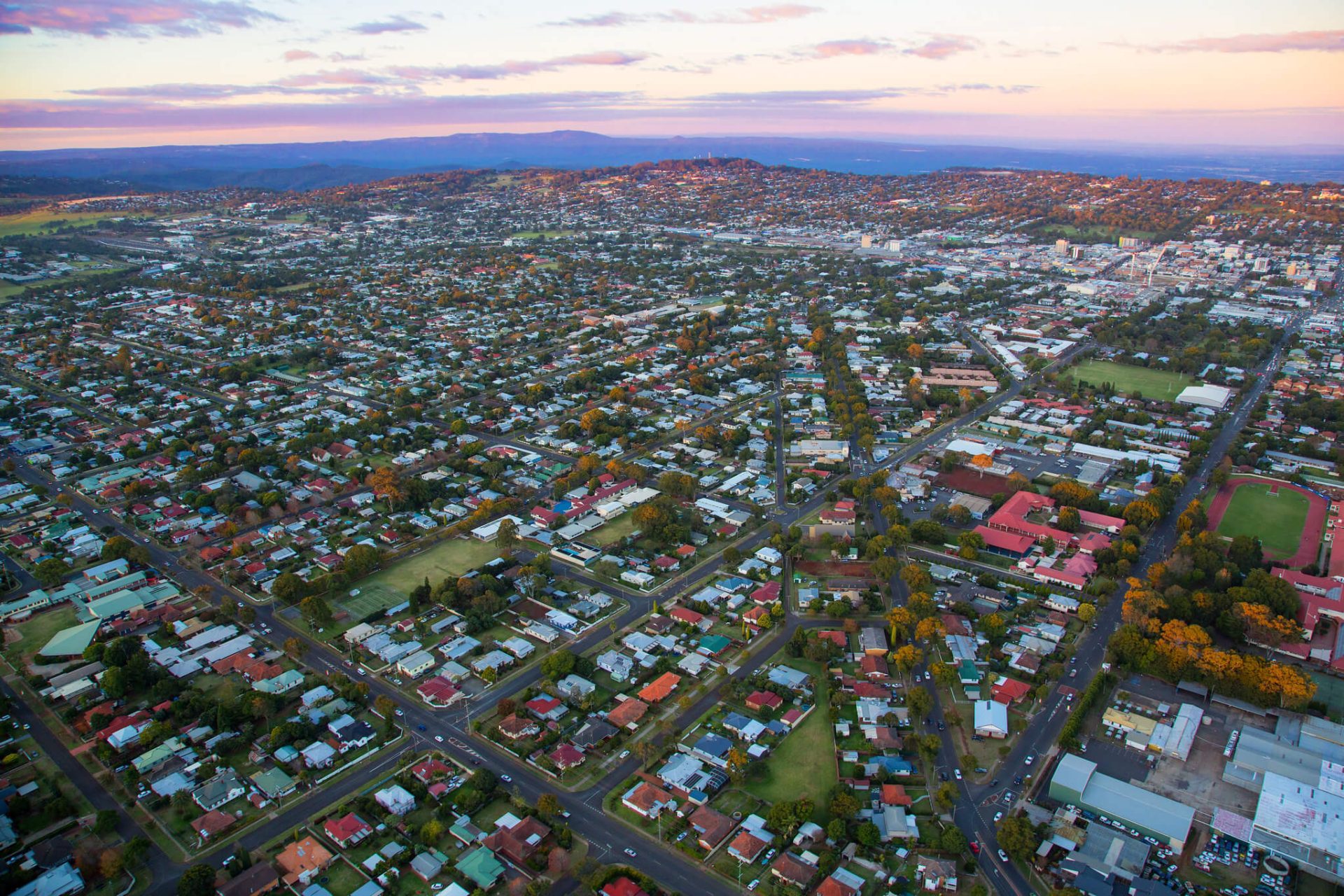
^ Toowoomba ^
Intermediate Sprints:
KM 41 – Ipswich
KM 149 – Hampton
GPM:
Cat. 4 - Unnamed - KM 120 - 7km - 310hm - Average: 4,4% - Max.: 6% (KM 118)
Pave Sectors:
-
Last 10 km: 1, 1, 2, 0, -2, -2, -1, 1, -1, -1
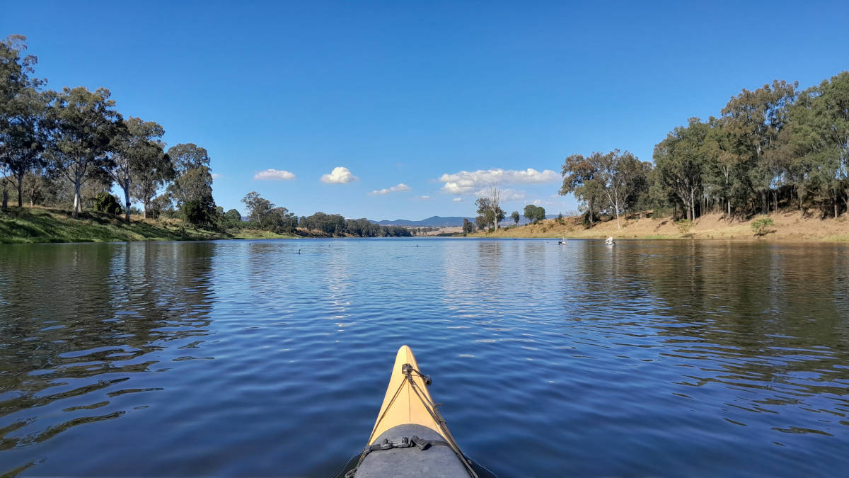
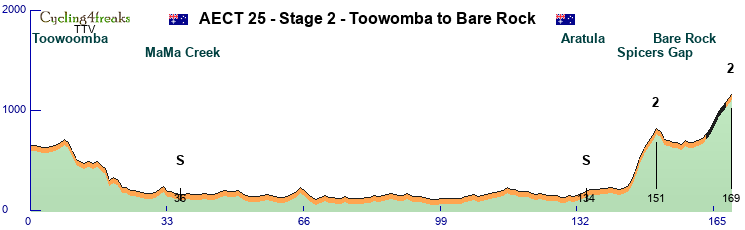
Stage 2 – Toowoomba to Bare Rock – Middle Mountain Stage - 169 km – 1.940 hm – Mintact at KM: 144 – Stage duration: 99 min

After a hopefully nice night the riders will start in Toowoomba to see for the first time what kind of mountains Australian East Coast Territory has to climb for them.
First the riders take the direct way back into the direction of the east coast. After a downhill they pass MaMa creek a little village with war memorial. Therefor the first sprint will take place there.
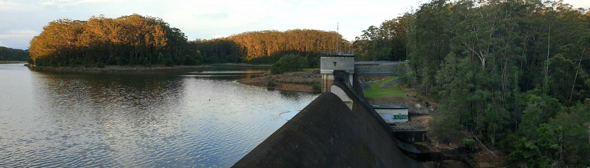
Before reaching Ipswich the route turns south passes Aratula near Lake Moogerah (remember that name already for the next days!) and we have the second sprint of the day there.
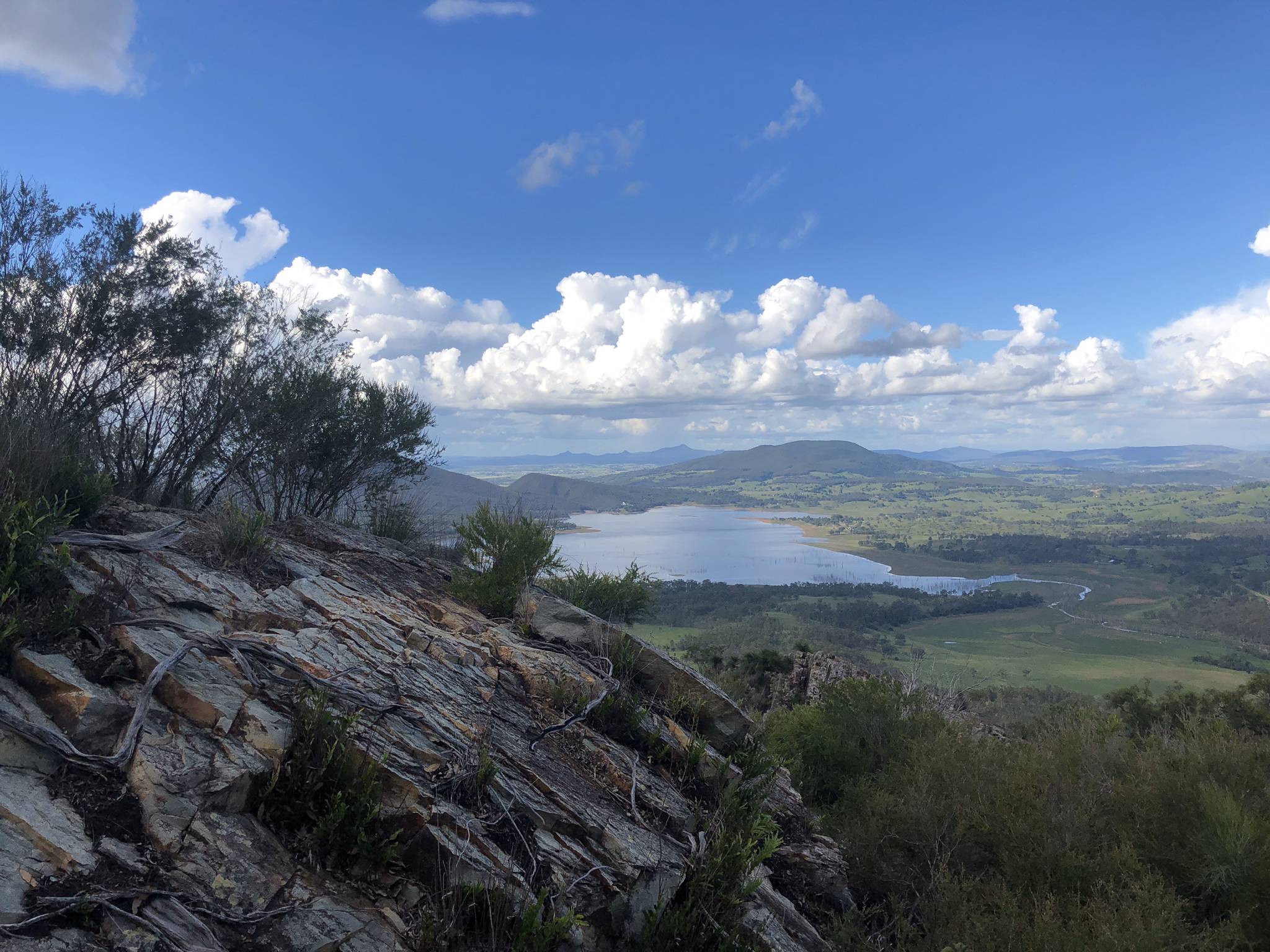
^ View to Lake Moogerah ^
Until here everything was flat and easy but the riders have to take now the short but especially in the first km steep Cat. 2 climb so spicers gap before around 10kms of short downhill and flat leave the teams time to regroup and maybe rethink their final strategy for the gravel road thats leaving the highway on Cunninghams gap to lead over 6 hard km up to the famous Bare Rock Viewpoint.
^ Bare Rock ^
Intermediate Sprints:
KM 36 – MaMaCreek
KM 134 – Aratula
GPM:
Cat. 2 - Spicers Gap - KM 151 - 7 km - 580 hm - Average: 8,3% - Max.: 12% (KM 147) - 6, 10, 12, 11, 6, 6, 7
Cat. 2 - Bare Rock - KM 169 - 7 km - 440 hm - Average: 6,3% - Max.: 9% (KM 166) - 5, 5*, 8*, 9*, 5**, 5**, 7
Pave Sectors:
Bare Rock: KM 164-168 - 5*, 8*, 9*, 5**, 5**
Last 10 km: 0, 2, 2, 5, 5*, 8*, 9*, 5**, 5**, 7
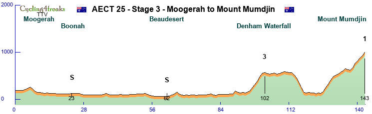
Stage 3 – Moogerah to Mount Mumdjin – Hilly Stage - 143 km – 1.820 hm – Mintact at KM: 124 – Stage duration: 81 min

The wonderful lake view at Lake Moogerah should inspire some riders today maybe to try something e.g. taking some money on the road or a stagewin at the in terms of percentage and length clearly hardest mountain of the first week. Some riders even mumble it could be depending on how the tour is ridden beeing the big gc decider.
But well lets start with the Lakeview heading back east via the coast and passing Boonah and Beaudesert on the highway where the IS money of the day can be taken on a stage that is nearly completely flat in its first two thirds.
Around 10km before reaching the coast the track turns south passing Canungra on the Beechmont Highway and then steepening up to the Denham Waterfall where points worth a Cat. 3 can be taken - Here riders have to take attention as the final km of the climb is only a 1.
^ Beechmont Highway near Denham Waterfalls ^
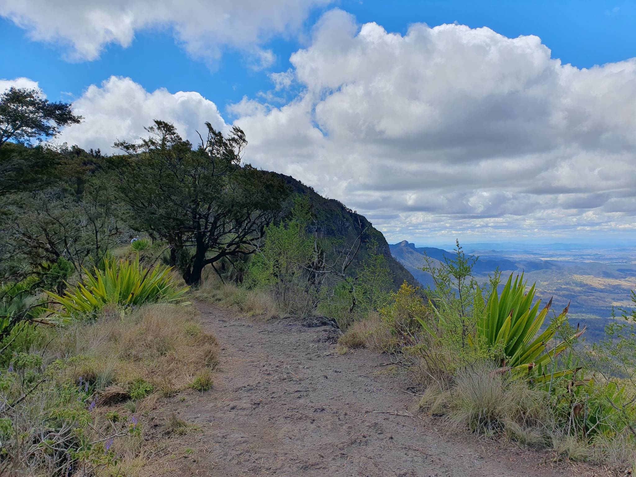
This climb around 40km from the finish is also the last and only chance to weaken other teams before the final starts. The road continues flat before falling to Advancetown lake. At its south end the pine Creek road will follow the track steeply up before a flatter middle part and the hard finish to Mount Mumdjin (Cat. 1) which is also called "Best of all lookout" on a narrow but perfectly asphalted road.
One thing is sure - Whos not among the best today will have a hard time trying to win that tour!
^ View from Mount Mumdjin ^
Intermediate Sprints:
KM 23 – Boonah
KM 62 – Beaudesert
GPM:
Cat. 3 - Denham Waterfall - KM 102 - 6 km - 390 hm - Average: 6,5% - Max.: 10% (KM 100)
Cat. 1 - Mount Mumdjin - KM 143 - 18 km - 870 hm - Average: 4,8% - Max.: 9% (KM 127, 139) - 4, 9, 7, 8, 8, 3, 2, 4, 2, 6, -3, -1, 6, 9, 5, 7, 5, 6
Pave Sectors:
-
Last 10 km: 2, 6, -3, -1, 6, 9, 5, 7, 5, 6
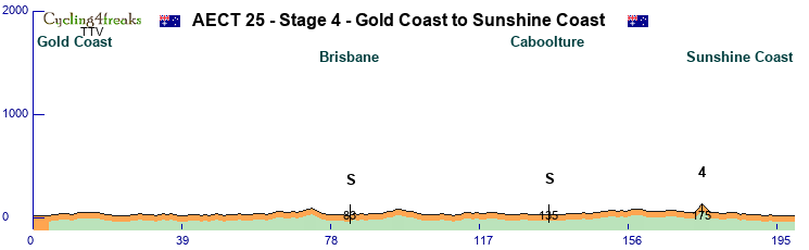
Stage 4 – Gold Coast to Sunshine Coast – Flat Stage - 199 km – 590 hm – Mintact at KM: 190 – Stage duration: 104 min

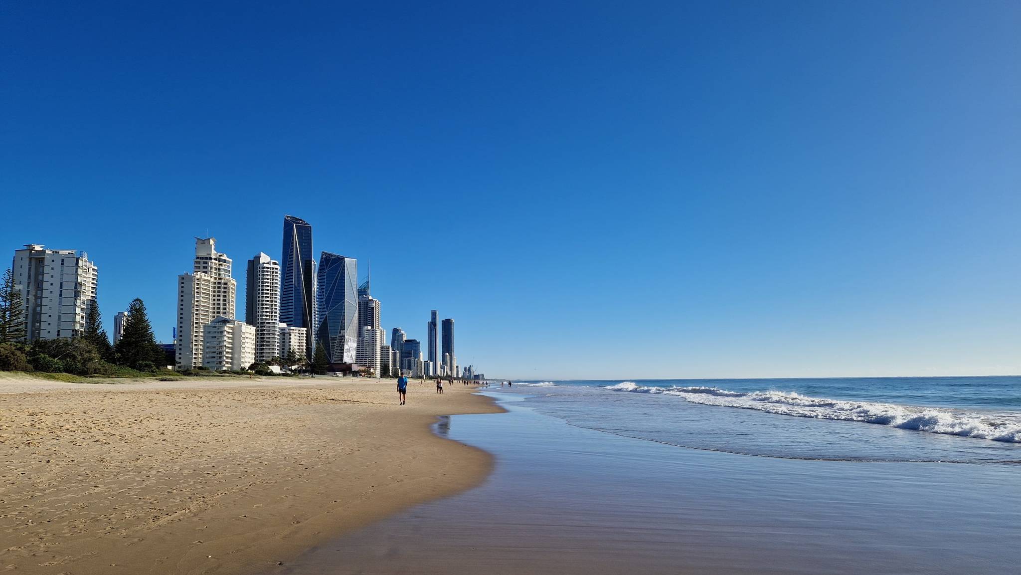
^ Gold Coast Beachfront ^
Back to the sea - up to wonderful Gold Coast ... one of Australias most famous beachfronts together with an impressing skyline are the starting place for stage 4 that should be a clearly signed win for the sprinting teams. IF they dont let a sneaky escaper through.
From the start near the beachfront the road heads all the way northwards. First we are passing Brisbane from a second time this time completely from south to north and will also see a sprint at the point at Roma street parklands the tour started 4 days ago.
^ Roma Street Parklands ^
After passing Brisbane the ride goes straight on north always between 5 and 15km from the coastline passing Caboolture city where we see the second and last sprint of the day. The road the stays flat until Moololah just 25km from the finish. A double 4 (Cat. 4) will give the only chance to sieb some really weak riders away before the flat chase continues until Sunshine Coast the second very well known Beach place at Australian East Coast. Riders can have a pleasant evening in one of the famous beach bars maybe.
Intermediate Sprints:
KM 83 – Brisbane
KM 135 – Caboolture
GPM:
Cat. 4 - Unnamed - KM 175 - 2 km - 80 hm - Average: 4,0% - Max.: 4% (KM 174, 175)
Last 10 km: 0, -1, 0, 1, -1, 0, 0, 0, 0, 0
Stage 5 – Sunshine Coast to Coolobalin Dam – Middle Mountain Stage - 166 km – 1.700 hm – Mintact at KM: 140 – Stage duration: 96 min
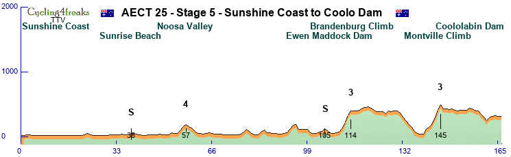

Stage 5 - The first one where classics should be the kings of the road in the finish. But we will see. The first part is again some nice coast ride starting at Sunshine Coast more far north passing famous Sunrise beach where we see a IS and finally reaching Noosa Heads a national geographic landmark.
^ Noosa Beach ^
From there we leave the coast going west inside the land to Noosa Valley where a short climb (Cat. 4) will leave some money on the road.
The road goes southwards passing the cities of Nambour and Palmwoods. At both places riders could use shortcuts now to the finish but instead the road becomes more and more hilly and maybe someone tries to get rid of the sprinters as the second IS at KM 105 is anyway after a 4 up to the Even Maddock Dam.
This is also the turning point of stage characteristics as the steep Brandenburg Climb (Cat. 3) will be a point to get rid of some riders if you prepare maybe an offensive strike towards the finish and your team is strong enough.
^ Brandenburg Climb ^
The road flattens but still goes up a bit after the GPM before a downhill brings the riders down to Montville. From here it could be an easy finish but the organisation team decided to let the riders ride the steep "Razorback" climb which has two very hard km (Cat. 3).
Now the classics have to be fit and fast on the last 20km to catch everyone back on a nearly flat and downhill course that includes still a tricky 5 shortly before the finish line that will be near the Coolobalin dam.
^ Coololabin Dam ^
Intermediate Sprints:
KM 36 – Sunrise Beach
KM 105 – Even Maddock Dam
GPM:
Cat. 4 - Noosa Vally - KM 57 - 3 km - 130 hm - Average: 4,3% - Max.: 6% (KM 56)
Cat. 3 - Brandenburg - KM 114 - 4 km - 330 hm - Average: 8,3% - Max.: 10% (KM 112, 113)
Cat. 3 - Razorback - KM 145 - 6 km - 450 hm - Average: 7,5% - Max.: 13% (KM 144)
Pave Sectors:
-
Last 10 km: -3, -1, -5, -4, -5, 5, 1, 1, -1, 0
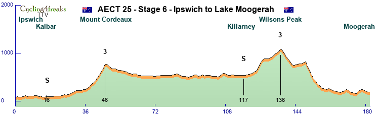
Stage 6 – Ipswich to Lake Moogerah – Flat Stage - 182 km – 1.790 hm – Mintact at KM: 170 – Stage duration: 97 min

The last day in Queensland and before the rest day will bring the riders back to some places they have seen in the days before. Still they will know only around 5km of the stage already. It starts in Harrisville a small village a little south of Ipswich and goes south to Kalbar where at KM 16 we have an IS before at Aratula the riders come back on the road they have already taken on the Bare Rock stage. They also ride to Cunninghams Gap today but not the way they did on day 2 but from the other side, which makes the climb much easier.
^ Cunninghams Cap / Mount Cordeaux ^
Instead of taking the gravel road to bare rock the riders stay on the highway this time before leaving it to the south leaving out the city of Warwick on the next 70km and instead heading to Killarney for the second sprint of the day.
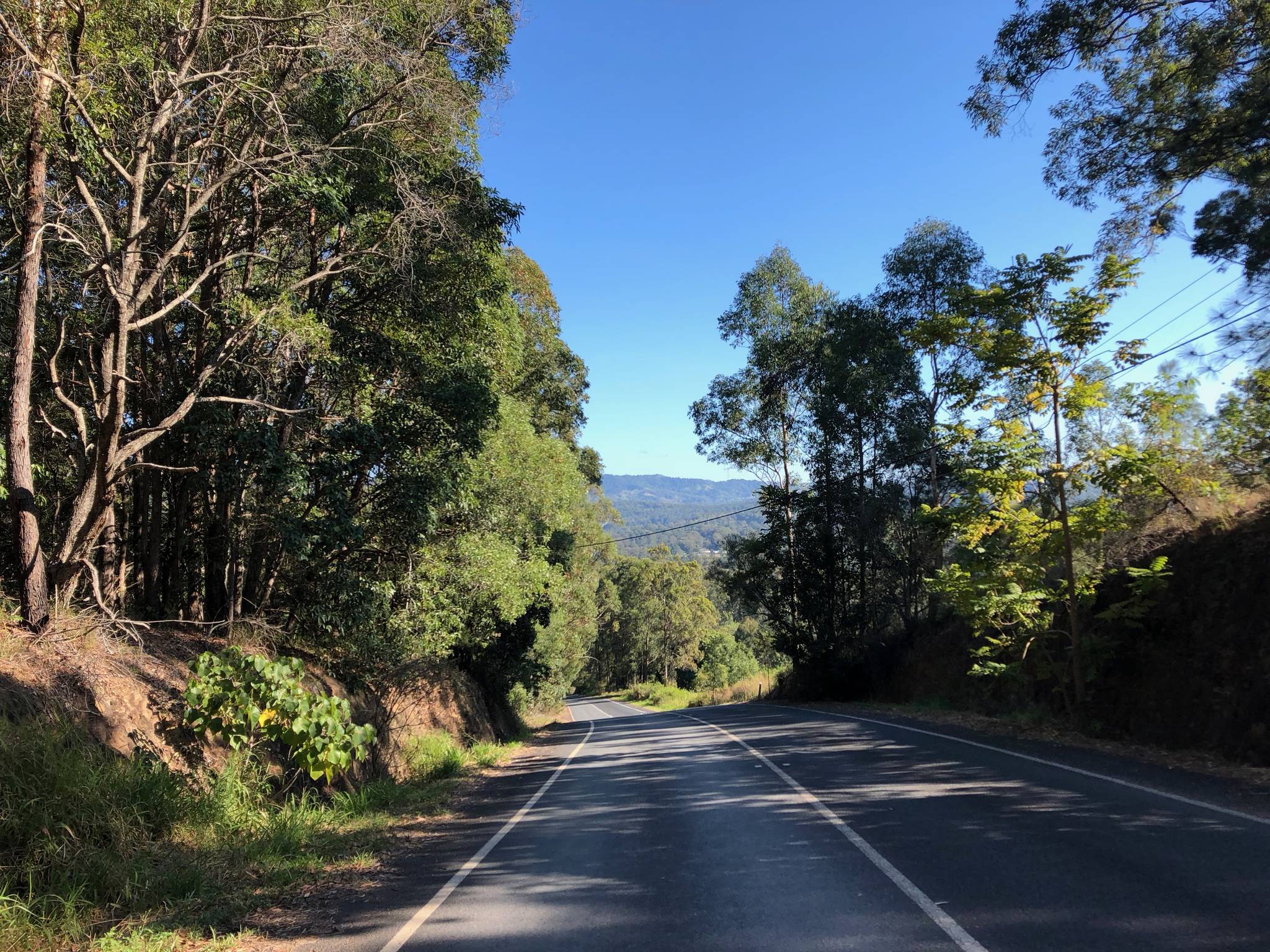
^ Road shortly after Killarney ^
Two very steep km in the beginning of the long climb to Wilsons Peak might hurt sprinter teams very much but still if they are absolutely organized they will have 55km of downhill and flat to catch the classics back. But they should be aware as also the final km have some hills in it so at least one fit blocker will be needed for the sprinter teams against late classic attacks.
Intermediate Sprints:
KM 16 – Kalbar
KM 117 – Killarney
GPM:
Cat. 3 - Mount Cordeaux - KM 46 - 10 km - 530 hm - Average: 5,3% - Max.: 8% (KM 46)
Cat. 3 - Wilsons Peak - KM 136 - 14 km - 490 hm - Average: 3,5% - Max.: 9% (KM 125, 126)
Pave Sectors:
-
Last 10 km: -1, -1, -1, 4, 2, 4, -4, -1, -2, 0
REST DAY - Transfer to Newcastle
After a long ride (740km) to the south riders will really have time to rest for a day before the next difficulties are awaiting with some hard surprises.
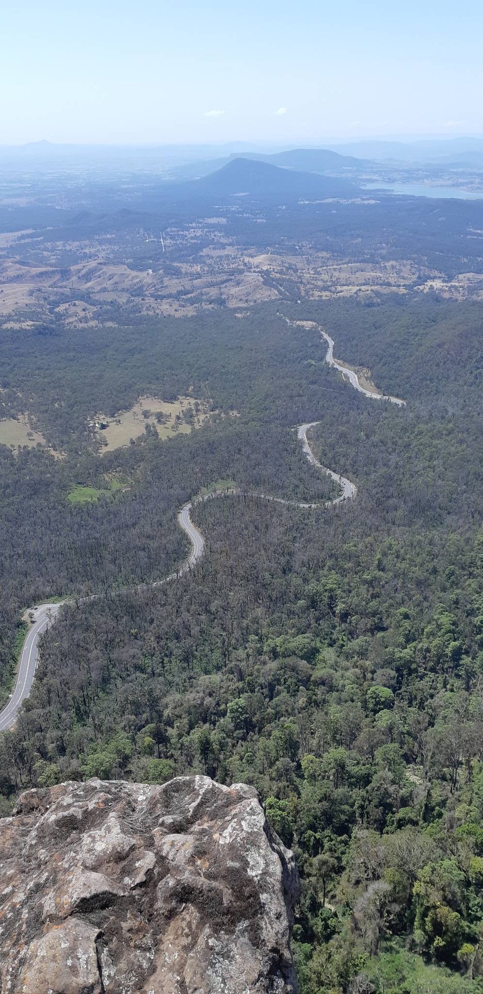
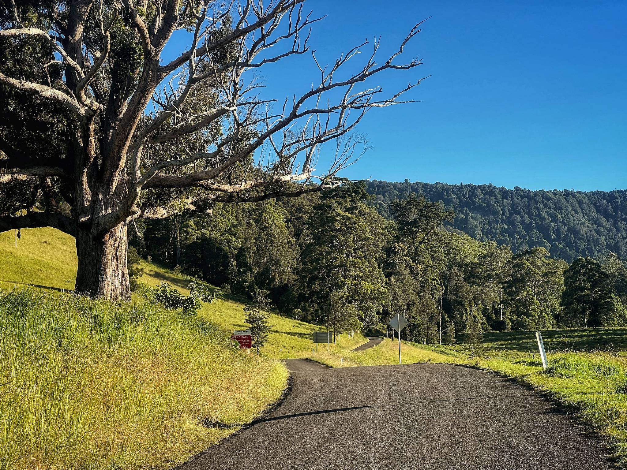
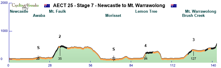
Stage 7 – Newcastle to Mount Warrawolong – Middle Mountain Stage - 143 km – 1.610 hm – Mintact at KM: 120 – Stage duration: 83 min

New South Wales is awaiting the riders and Newcastle directly on the Coast Line is happy to present the start of week 2 with a stage that might be very decisive for gc already. But lets start and see. The first 30 kms are just simple and flat rolling out of Newcastle mostly southwest to Awaba Village with an IS.
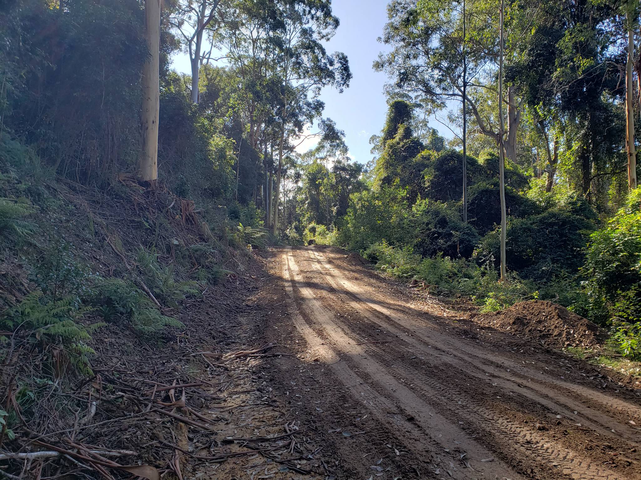
After that the road gets unpaved but still nice to ride up to Mt. Faulk (Cat. 2) with some steep km and a 0 for the mountain price. Directly after the roads gets even a little worse so we see some ** pave km there. Luckily the government offered help and asphalted here the downhills and an additional part of around 10km so the race can take place along the wonderful scenery of Watangan Forest.
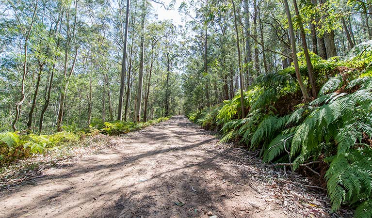
^ One of the left unpaved parts in Watagan national park ^
After a scenic flat ride through the forest park and a downhill riders come back near to the coast passing Morisset on aspalted roads where we see IS Number two of the day.
The road then takes the steep asphalted climb to Lemon Tree which might remember riders of the famous song if they have time for it in this possible hot situation. After the climb another few gravel roads wait until the riders are back on the main road.
Now 25km time to regain power before the little climb to Brush Creek (Cat. 3) invites the riders for a hard finish on Mt. Warrawolong. Due to the special finish the organization comitee decided to not give mountain points there indeed.
^ Brush Creek ^
^ Mt. Warrawolong ^
Intermediate Sprints:
KM 20 – Awaba
KM 72 – Morisset
GPM:
Cat. 2 - Mt. Faulk - KM 35 - 6 km - 400 hm - Average: 6,7% - Max.: 11% (KM 32) - 3, 9*, 11*, 7*, 10*, 0
Cat. 3 - Brush Creek - KM 126 - 7km - 290 hm - Average: 4,1% - Max.: 6% (KM 121, 126)
Pave Sectors:
Mt. Faulk: KM 31-34 - 9*, 11*, 7* 10*
Watagan Forest: KM 36-40 - 3*, -1**, -2**, -2**, -2*
Lemon Tree: KM 95-99 - 2*, -1**, 1**, 0*, 1*
Brush Creek: KM 124-126 - 5*, 3*, 6*
Walkers Ridge: KM 136-137: 3***, 3**
Mt. Warrawolong: KM 140-143 - 0***, 1**, 3***, 12***
Last 10 km: 2, 0, 3***, 3**, 1, 0, 0***, 1**, 3***, 12***
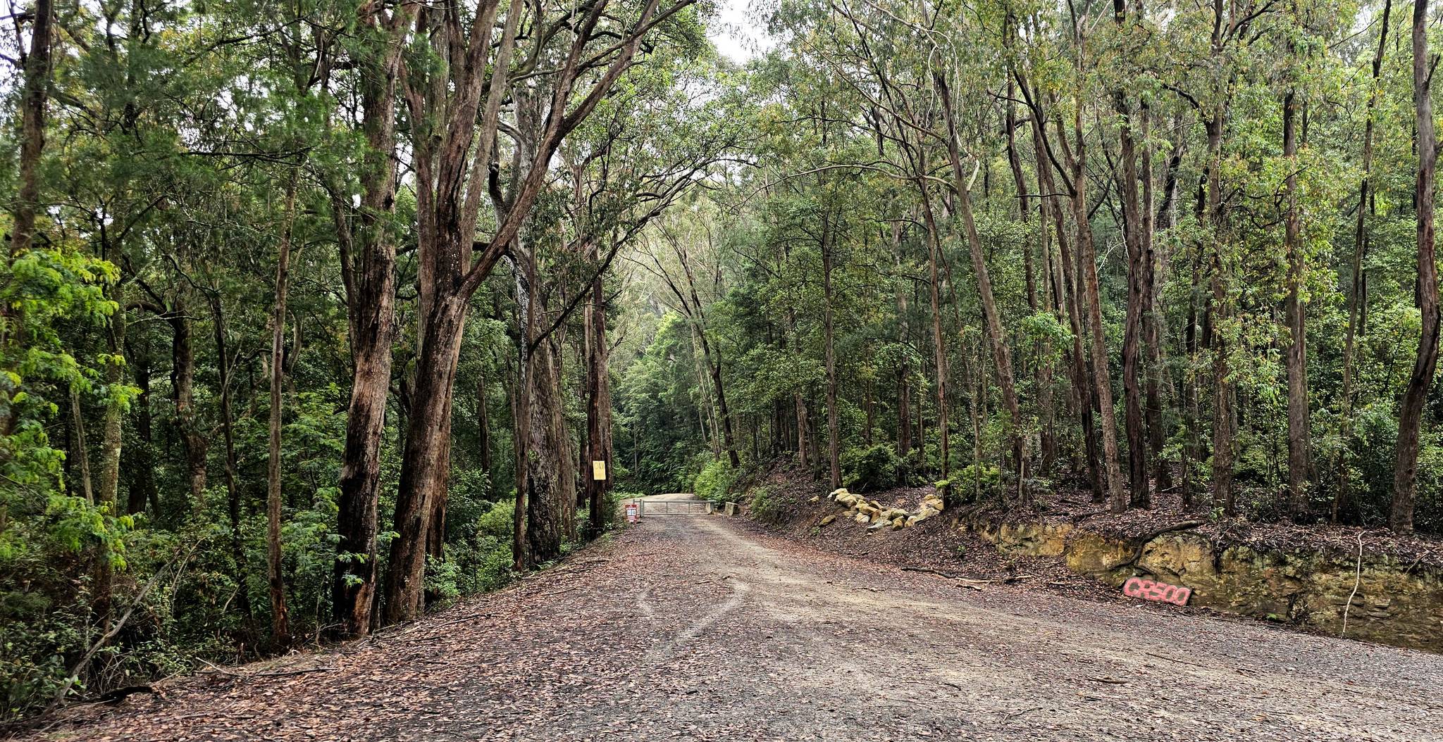
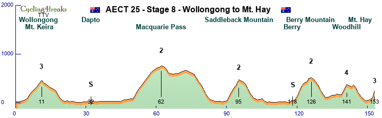
Stage 8 – Wollongong to Mt. Hay – Middle Mountain Stage - 153 km – 2.800 hm – Mintact at KM: 120 – Stage duration: 93 min

After the hard pave the day before which might have brought some riders under reg todays stage seems to be made for a brave escaper that could also gain big time in gc.
The day starts again directly at the Seaside in Wollongong the 3rd biggest city in the state of New South Wales.
Directly after the start the riders are awaited by the climb to Mt. Keira which has some pleasant views over Wollongong but also some steep km on a narrow asphalted road.
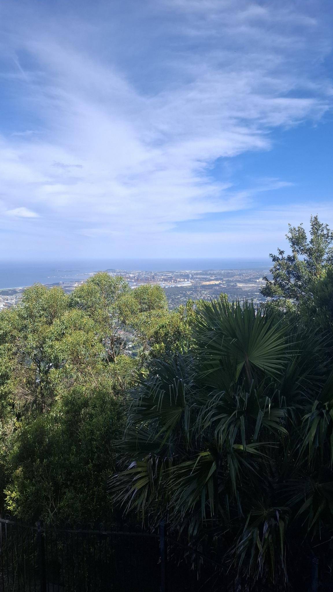
^ View over Wollongong from Mt. Keira ^
A downhill back to the coast gives the riders 40km time to form a decent group before the very hilly last 100km of the stage start with the by numbers hardest climb up to the Macquarie Pass (Cat. 2) that is heard especially in the beginning. After reaching the top of the climb maybe a pie would fit for some riders. Good that famous Robertson Pie Shop lies on the way!
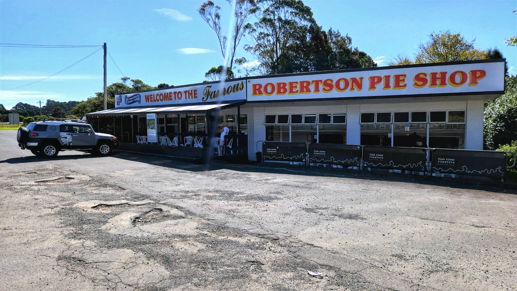
^ Pie for all ^
A steep downhill brings riders nearly back to the coast but just before reaching it they turn south again for the Saddleback climb which is shorter but steeper then Macquarie Pass (Cat. 2).
The following downhill leads riders back to the last longer flat part of the race ending with the second IS of the day in Berry.
On the last 40km 3 more categorized climbs await the riders with the Berry Mountain beeing the first of them (Cat. 2) the woodhill climb (Cat. 4 but very steep) and the extremely hard final on Mt. Hay (Cat. 3).
^ Look from Mt. Hay ^
Intermediate Sprints:
KM 32 – Dapto
KM 118 – Berry
GPM:
Cat. 3 - Mt. Keira - KM 11 - 7 km - 400 hm - Average: 5,7% - Max.: 8% (KM 6)
Cat. 2 - Macquarie Pass - KM 62 - 12 km - 670 hm - Average: 5,6% - Max.: 9% (KM 52) - 8, 9, 7, 6, 7, 6, 6, 7, 3, 4, 1, 3
Cat. 2 - Saddleback Mountain - KM 95 - 5 km - 430 hm - Average: 8,6% - Max.: 10% (KM 95) - 9, 9, 8, 7, 10
Cat. 2 - Berry Mountain - KM 126 - 7 km - 450 hm - Average: 6,4% - Max.: 11% (KM 121, 122) - 8, 11, 11, 5, 2, 7, 1
Cat. 4 - Woodhill - KM 141 - 2 km - 210 hm - Average: 10,5% - Max.: 11% (KM 140)
Cat. 3 - Mt. Hay - KM 153 - 2 km - 180 hm - Average: 9,0% - Max.: 14% (KM 153)
Pave Sectors:
-
Last 10 km: 4, -6, -9, -8, -5, -4, 1, 1, 4, 14
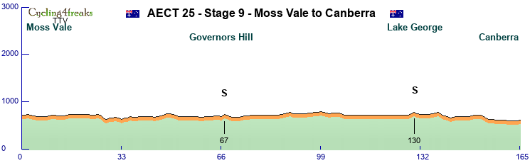
Stage 9 – Moss Vale to Canberra – Flat Stage - 165 km – 710 hm – Mintact at KM: 156 – Stage duration: 85 min

2 hard days have gone by... so its time to give the sprinters some chances again - and this one might be besides stage 4 clearly the easiest to achieve a sprint.
Starting in Moss Vale a bit south west inside the land of Wollongong the stage starts directly southwest on the highway. Before reaching Goulburn with the Big Merino (sheep) statue the Governors Hill will be taken where we see a sprint on a +4.
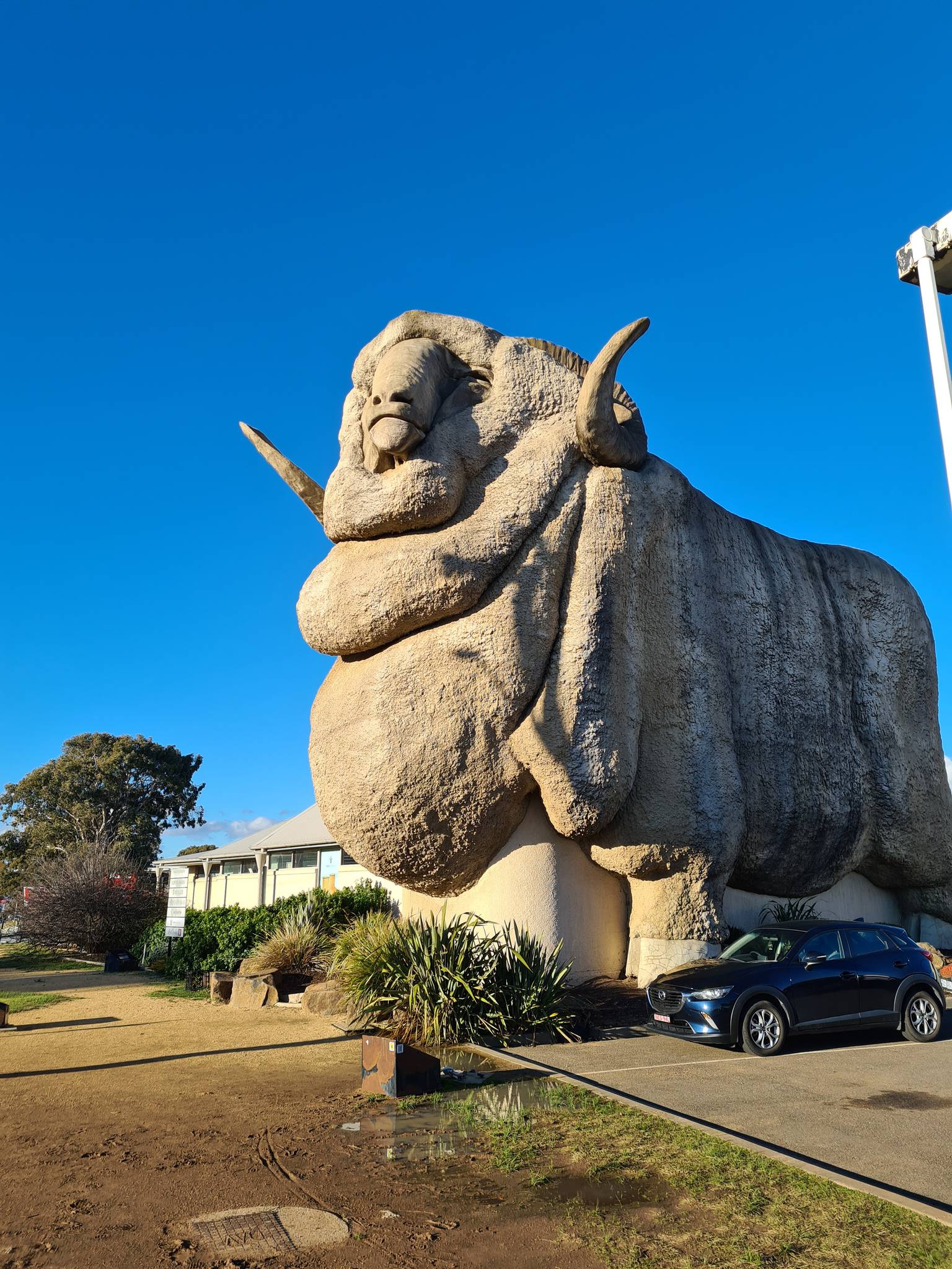
^ Big Merino in Goulburn ^
While the sheep stays in Goulburn the riders continue to the south cycling on the old federal highway alongside Lake George where the last 4 of the day (no steeper km all day) will invite the riders to the second IS before the final 35 km lead them on flat easy streets to Canberra the capital of Australia! We will then most likely see a sprint directly in front of the house of parliament.
^ Old Federal Highway ^
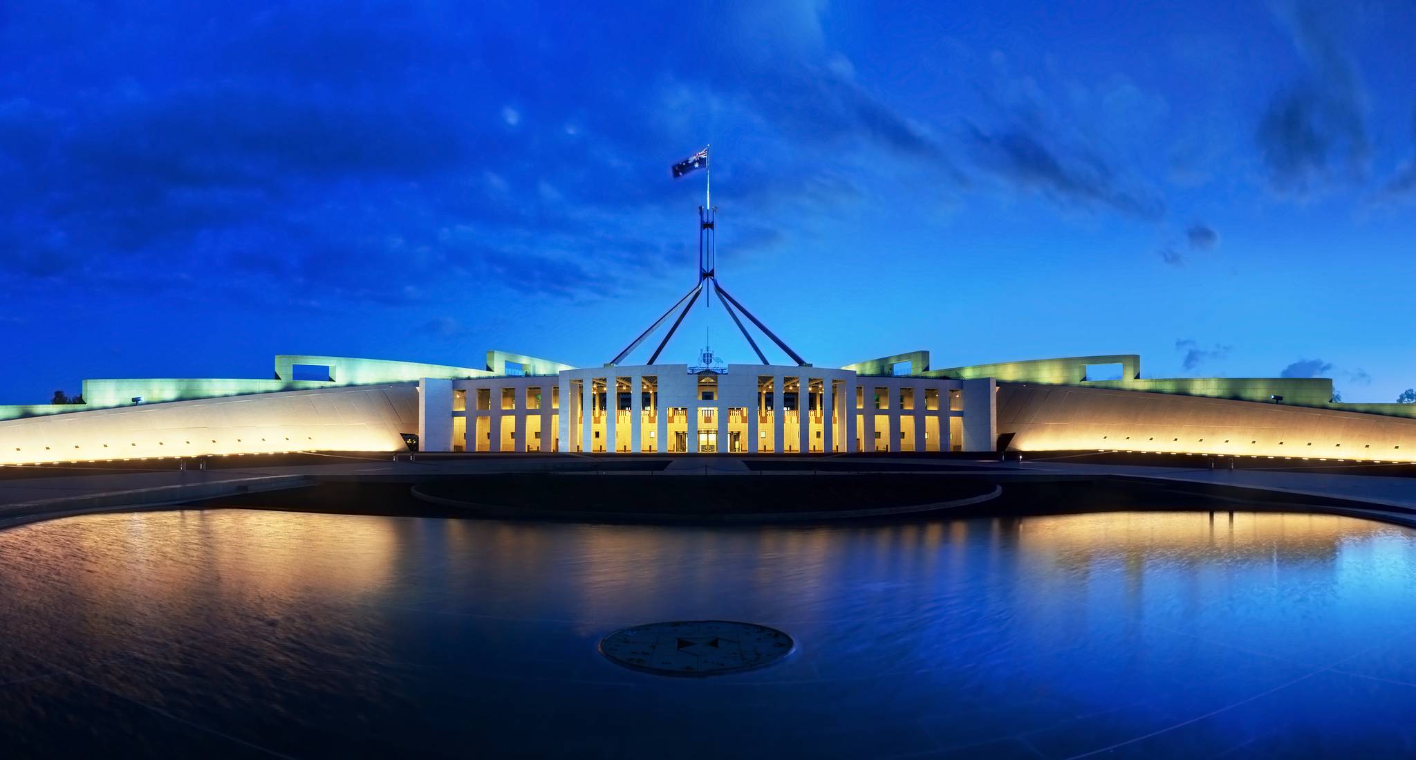
^ Australian Parliament House ^
Intermediate Sprints:
KM 67 – Governors Hill
KM 130 - Lake George
GPM:
-
Pave Sectors:
-
Last 10 km: -1, -1, 0, 0, 0, -1, 0, 0, 0, 1
Stage 10 – Canberra to Cooma – Flat Stage - 159 km – 1.360 hm – Mintact at KM: 136 – Stage duration: 91 min
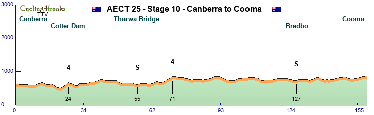

Starting in Canberra sprinters could on this transition stage into the mountains have another chance to win but it will definitely be harder then the day before.
Already in the beginning the riders dont use the easy and direct highway but a little more scenic road alongside Cotter Dam (Cat. 4) and just reaching back to the highway after around 50km in the south of Canberra on Tharwa Bridge where we see also the first sprint of the day.
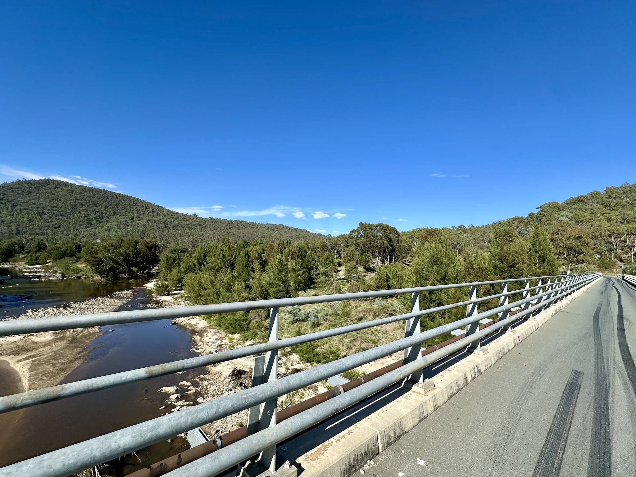
^ Road to Cotter Dam ^
The following road is pretty flat with only one categorized climb at KM 71 which will be to far from the finish to sieb the sprinters really away, but they still have to be aware as shortly after Bredbo (IS) and only about 20km from the finish a 5 and 15km before a 4 await the riders with maybe a chance to get rid of tired guys.
The finish then will take place in Cooma with is something like the opening place to the highest Australian mountains with a slight uphill finish (max. 2%)
^ Highway before reaching Cooma ^
Intermediate Sprints:
KM 55 – Tharwa Bridge
KM 127 - Bredbo
GPM:
Cat. 4 - Cotter Dam - KM 24 - 3 km - 150 hm - Average: 5,0% - Max.: 6% (KM 23)
Cat. 4 - Unnamed - KM 71 - 4 km - 170 hm - Average: 4,3% - Max.: 5% (KM 69, 71)
Pave Sectors:
-
Last 10 km: -2, -3, -1, 0, 1, 2, 2, 2, 1, 1
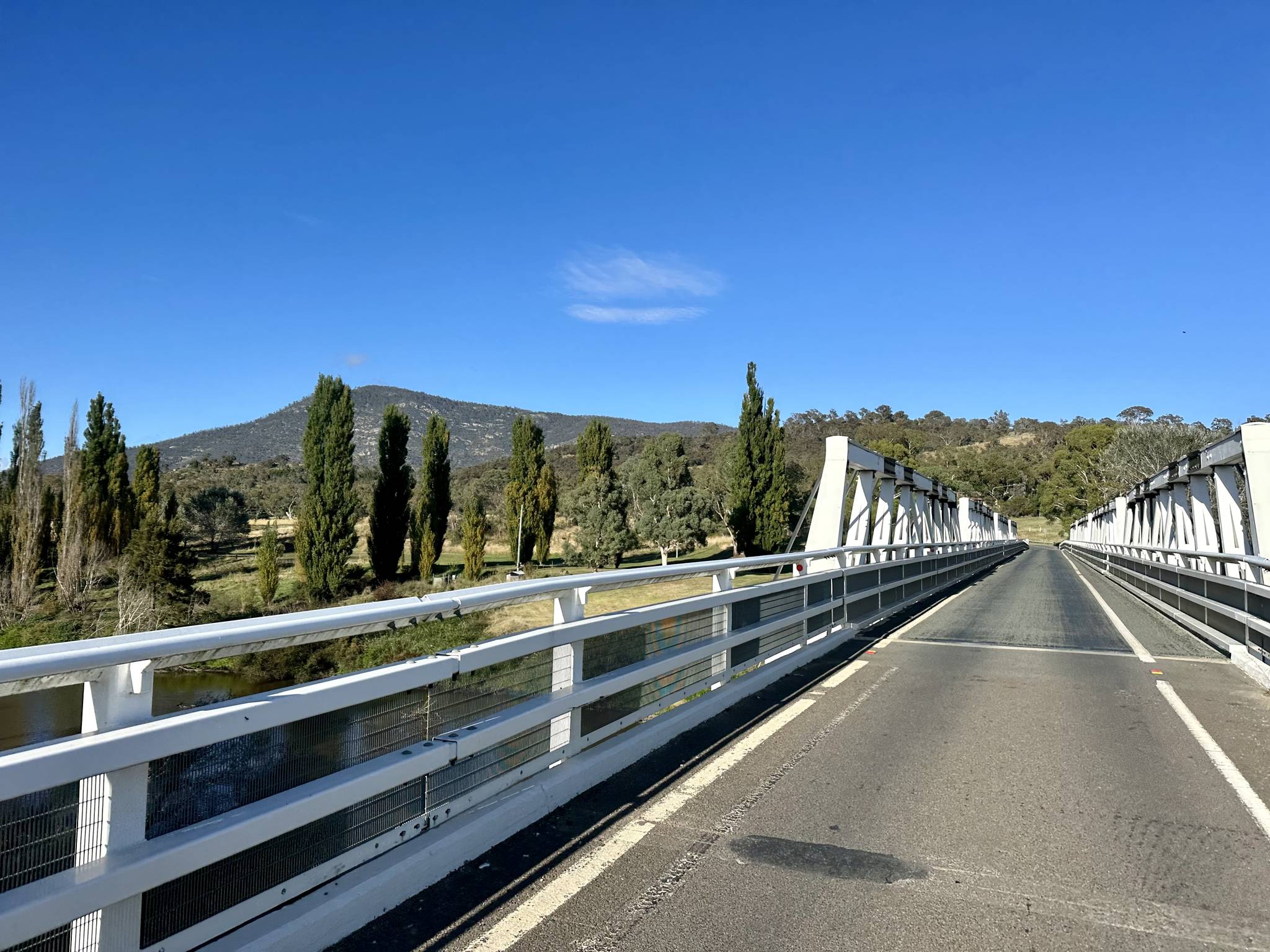
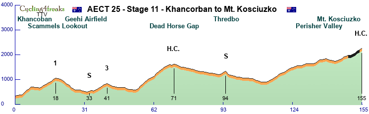
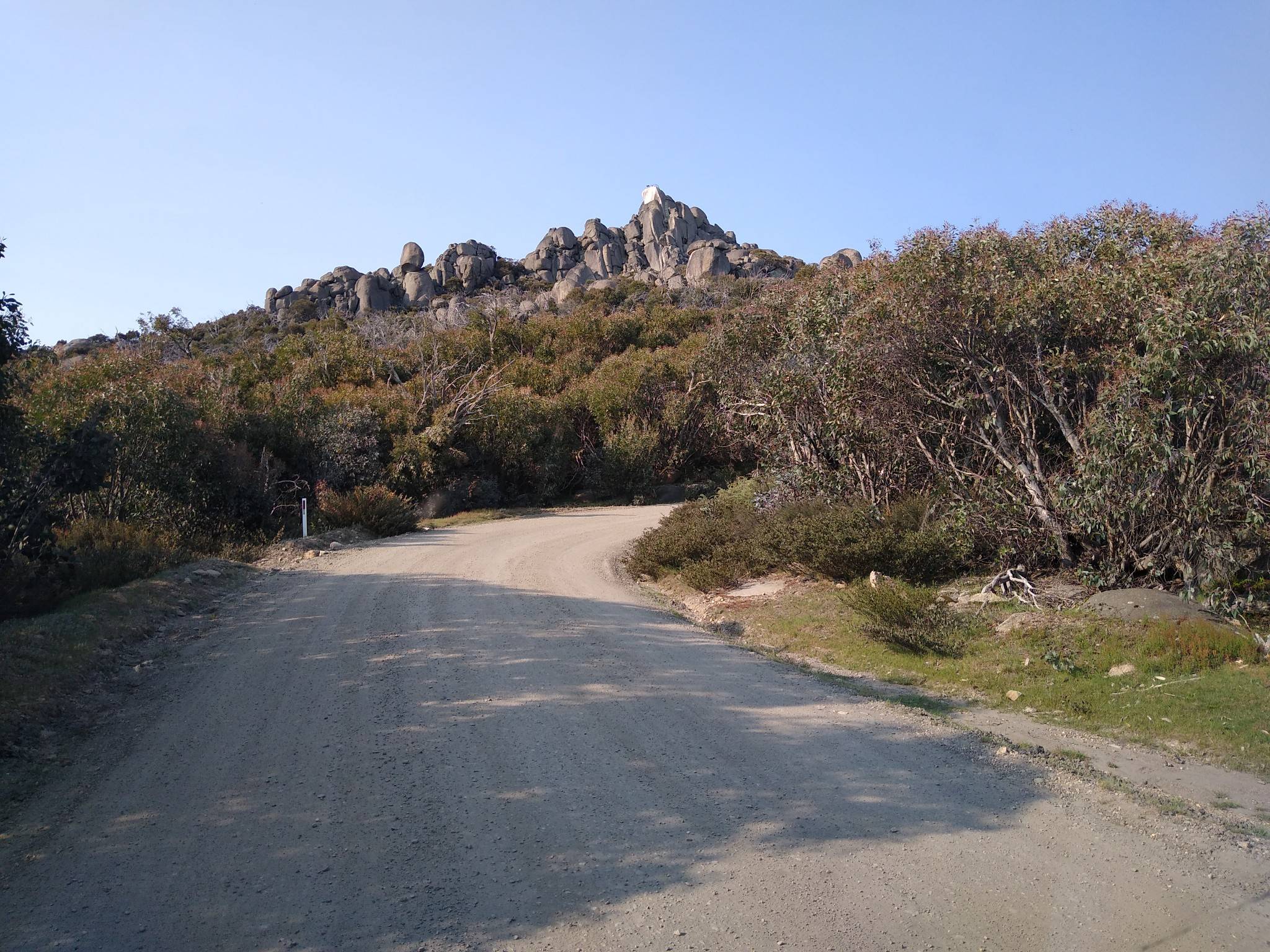
Stage 11 – Khancoban to Mt. Kosciuzko – Mountain Stage - 155 km – 3.760 hm – Mintact at KM: 116 – Stage duration: 97 min

Khancoban a small village in the western Snowy mountains that was founded when the Snowy mountains plant system was built hosts the first real mountain stage of this year. According to the hm it might be the hardest stage but its even not assured that a mountain rider will win it in the end.
First the road goes to the south passing the firs thard climb of the day at Scammels Lookout (Cat. 1).
^ Scammels Lookout climb ^
After the downhill riders will pass Geehi Airfield in the middle of the mountains where a sprint takes place before the first really well known climb up to the Dead Horse Gap (Cat. 1) in the Great Dividing Range starts.
^ Dead Horse Gap ^
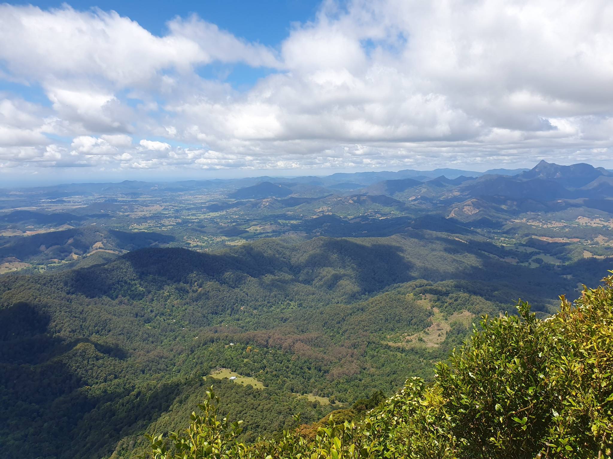
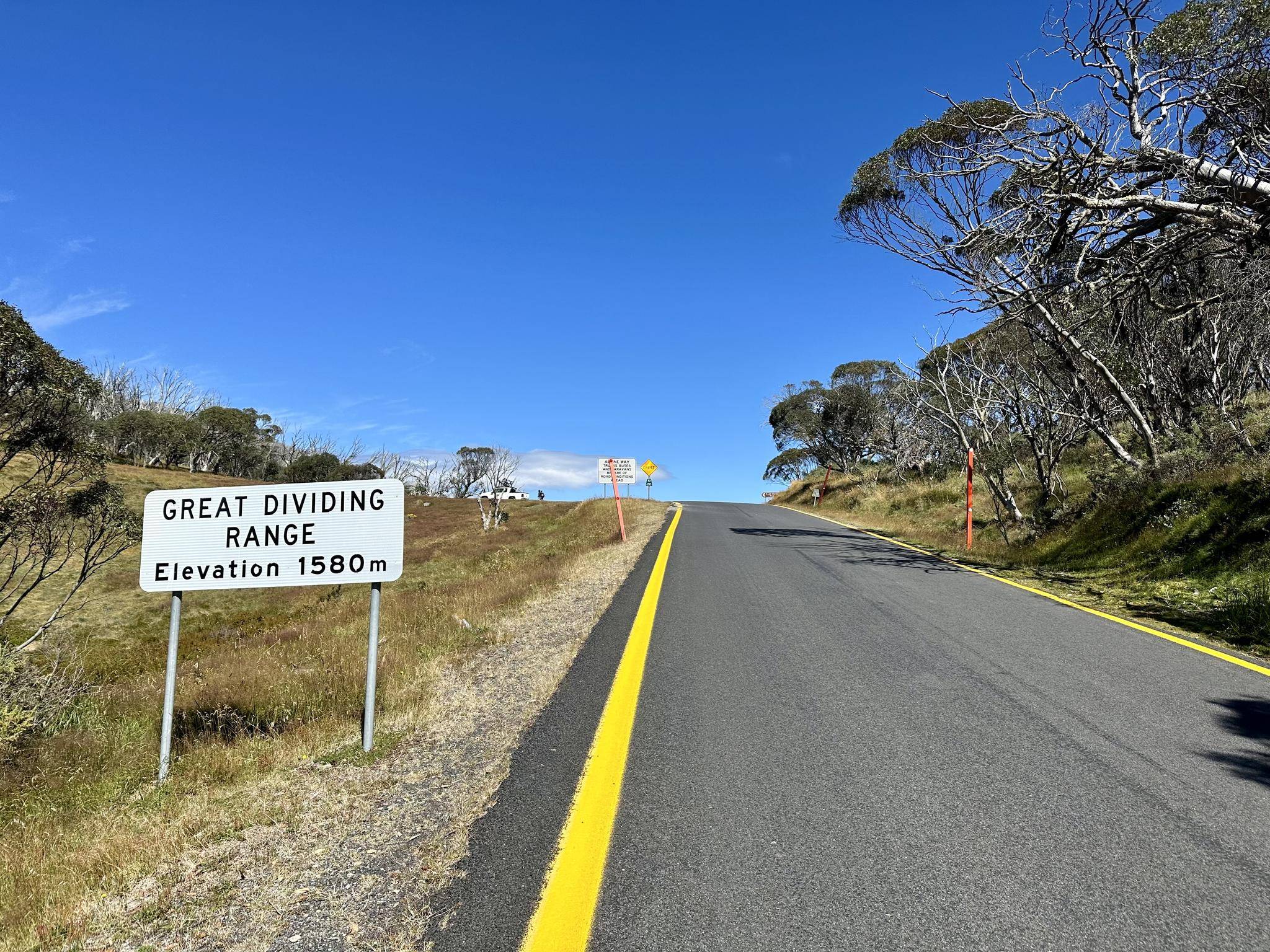
On the way down from the pass the riders will have to pass a short climb back to Thredbo Village one of the oldest Australian skiing resorts where we will see a sprint. All in all the downhill is not that steep and so riders will be still nearly at 1000 meters above sealevel when the big long final climb starts. This climb will lead the riders over Perisher Valley to Mt. Kosciuzko (H.C.) the highest point on Australian territory. We are thankful to the government that for once allowed to use the last 5km of the hiking trail for cycling up by leaving the fixed stairs there out. As the climb is very long but all in all not steep we will see who will be king of Australia tonight!
Intermediate Sprints:
KM 33 – Geehi Airfield
KM 94 - Thredbo
GPM:
Cat. 1 - Scammels Lookout - KM 18 - 15 km - 780 hm - Average: 5,2% - Max.: 10% (KM 4) - 10, 7, 7, 7, 0, -1, -1, -1, 5, 6, 5, 6, 5, 8, 7
Cat. 3 - Unnamed - KM 41 - 8 km - 320 hm - Average: 4,0% - Max.: 7% (KM 37, 39)
Cat. H.C. - Dead Horse Gap - KM 71 - 17 km - 1030 hm - Average: 6,1% - Max.: 11% (KM 56) - 5, 11, 7, 9, 8, 5, 4, 6, 10, 9, 5, 8, 6, 4, 4, -2, 4
Cat. H.C. - Mt. Kosciuzko - KM 155 - 42 km - 1330 hm - Average: 3,2% - Max.: 8% (KM 118, 136) - 7, 8, 0, 1, 2, -3, -3, -2, -1, 2, 3, 5, 7, 3, 4, 0**, 3**, 7**, 7**, 5**, 5 (from KM 135)
Pave Sectors:
Mt. Kosciuzko: KM 150-154 - 0**, 3**, 7**, 7**, 5**
Last 10 km: 5, 7, 3, 4, 0**, 3**, 7**, 7**, 5**, 5
Stage 12 – Benambra to Mount Buffalo – Mountain Stage - 191 km – 3.400 hm – Mintact at KM: 162 – Stage duration: 110 min
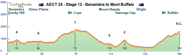

Before the last hard mountain stage only one thing is sure - After todays stage we will most likely know the winner of the Australian East Coast Tour 2025.
Starting in Benambra near to yesterdays finish the first 50km are more or less ouverture with only a Cat. 4 Mountain directly after the start and a sprint after 34km at Omeo Plains.
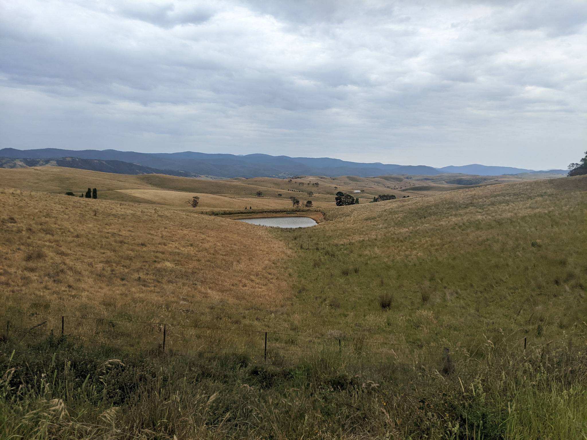
^ Smoky Hill ^
The first real difficulties start with the Mt. Cope (Cat. 1) a over 20km long climb that lacks of real steep km but will still be leading to some selection in the field for sure. The ride continues west all the time then plain and downhill to Mount Beauty village where we see the second IS of the day.
^ Mount Cope ^
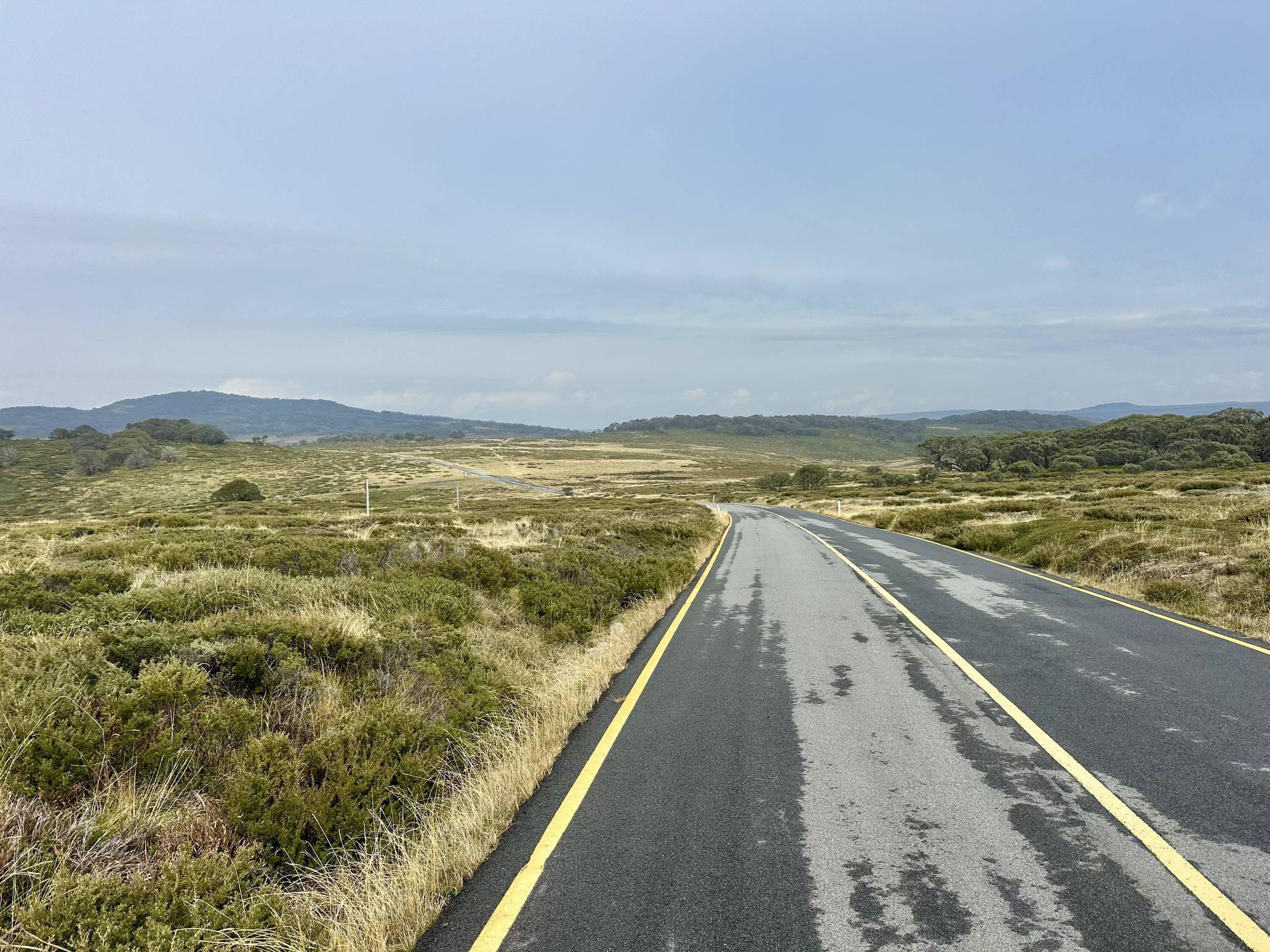
Directly after the IS the riders swap valleys via the Tawonga Gap (Cat. 2) and after passing the city of bright the last big climb of the tour starts to Mount Buffalo.
Today pretty sure a mountain rider can win but most likely the time gain on other riders aint big if we dont see a big attack. So who will be the final winner of the tour? Mountain rider? Even a Classic? Or just 80-70? Stay tuned!
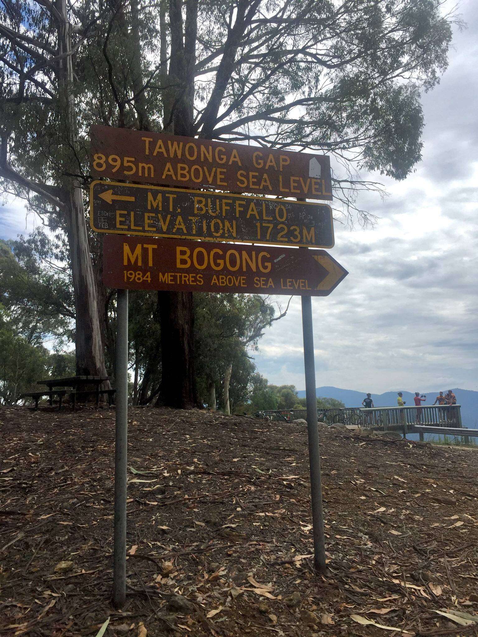
^ Tawonga Gap shows the way ^
^ Final climb to Mount Buffalo ^
Intermediate Sprints:
KM 34 – Omeo Plains
KM 113 - Mount Beauty
GPM:
Cat. 4 - Smoky Hills - KM 10 - 3 km - 150 hm - Average: 5,0% - Max.: 7% (KM 8)
Cat. 1 - Mount Cope - KM 75 - 23 km - 1030 hm - Average: 4,5% - Max.: 11% (KM 56) - 5, 8, 5, 11, 10, 7, 5, 6, 7, 0, 6, 0, 0, 0, 0, 3, 4, 5, 4, 0, 0, 7, 7
Cat. 2 - Tawonga Gap - KM 130 - 9 km - 520 hm - Average: 5,8% - Max.: 8% (KM 127, 129) - 4, 6, 6, 7, 6, 8, 4, 8, 3
Cat. H.C. - Mount Buffalo - KM 191 - 30 km - 1280 hm - Average: 4,3% - Max.: 8% (KM 166, 168, 174, 189) - 7, 5, 8, 6, 7, 4, 6, 3, -2, -2, -3, 6, 5, 4, 7, 1, 0, 8, 5, 6 (from KM 172)
Pave Sectors:
-
Last 10 km: -3, 6, 5, 4, 7, 1, 0, 8, 5, 6
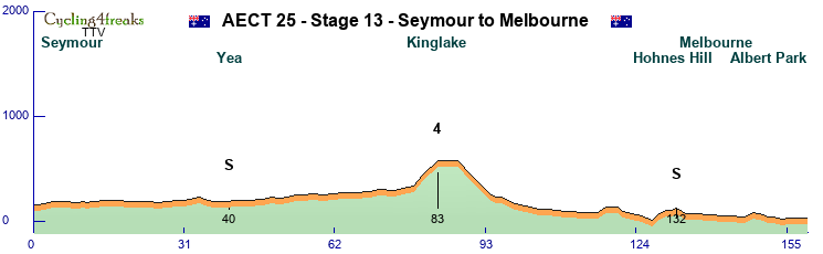
Stage 13 – Seymour to Melbourne – Flat Stage - 159 km – 760 hm – Mintact at KM: 150 – Stage duration: 84 min

After beeing transferred about 2 hours to the south the riders will sleep in the city of Seymour already in Victoria and near to Melbourne.
Today the sprinters will get the last chance for their jersey but also theoretically the mountain jersey could swap leaders a last time.
Instead of taking the direct highway to Melbourne riders leave the city of Seymour to the South East heading towards the small city of Yea where we will see another IS.
The following 40km the route goes towards south always a little upwards (<1% in total) before the Kinglake Climb will see the last mountain points of the tour.
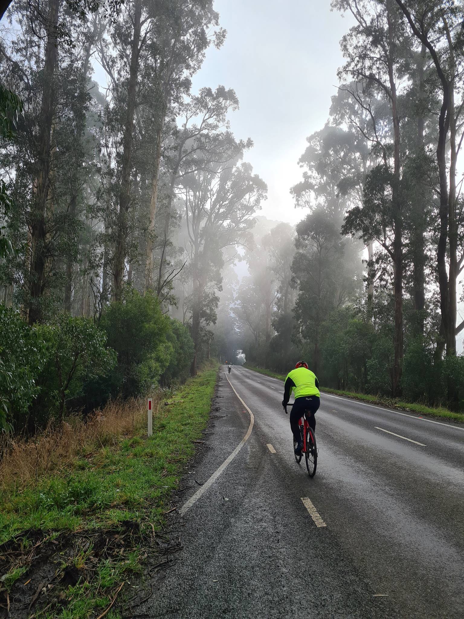
^ Kingslake road ^
Now the territory of Melbourne is nearly reached and after a downhill in the outer parts of Melbourne some little hills including a 5 30km from the finish around Hohnes Hill where also a sprint will take place are passed.
Now the route goes directly into the middle of Melbourne where the famous Albert Park Circuit will be our finishing spot for this tour.
We hope all riders had fun and their team managers too!
VOTE AECT 25!
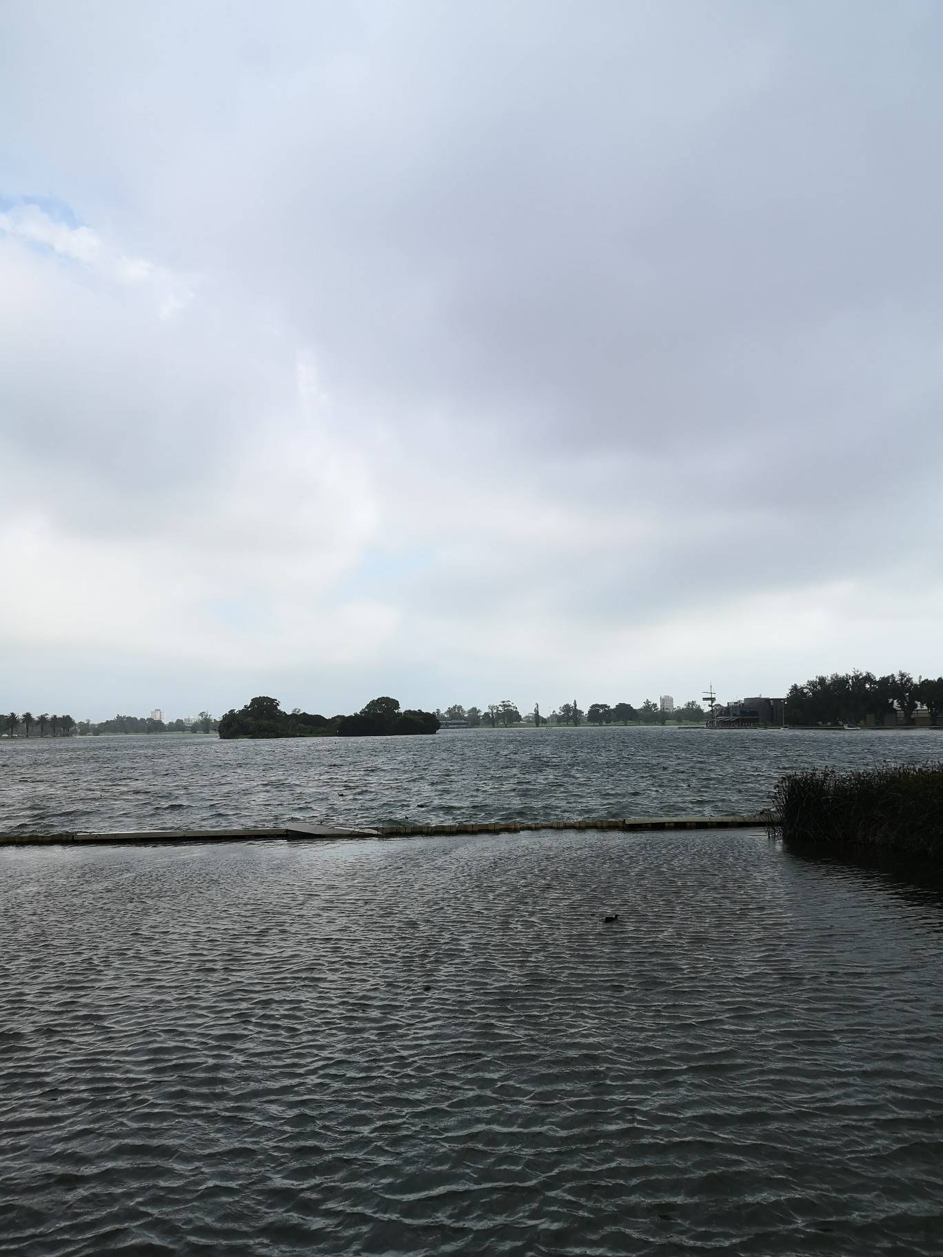
^ Finish back to the sea ^
Intermediate Sprints:
KM 40 – Yea
KM 132 - Hohnes Hill
GPM:
Cat. 4 - Kingslake - KM 83 - 5 km - 240 hm - Average: 4,8% - Max.: 6% (KM 80)
Pave Sectors:
-
Last 10 km: -1, -2, 0, -1, -1, 1, 0, 0, 0, 0
Introduction
Working where others go to holidays - Thats a dream that could come true for all cyclists if their managers vote for the "Australian East Coast Tour 2025". The tour is more or less divided into 2 parts. While the first 6 stages will take part in the state of Queensland in the territory between Gold- and Sunshine Coast around Brisbane, where the tour starts, the riders will be transferred to the state of New South Wales on the restday. From there on the next 7 Stages lead them south passing the capital Canberra and finally entering the state of Victoria where the tour will end in Melbourne.
Due to the very special geographics alongst Australian East Coast riders will find a variety of possibilities to show their strengths. While the real big mountains are lacking the organizing team found a huge amount of interesting roads that guarantee for races the riders will never forget (if in the good or bad way lies alone in their hands and the hands of their managers). This will feature some very tricky short climbs, some paved roads and some other surprises you can take from the roadbook.
General Information
9 riders per team
13 Stages + 1 Rest Day in total split into:
6 Flat Stages
5 Middle Mountain Stages
2 H.C. Mountain Stages
2.163 km in total
166 km per stage
24.000 hm in total
1.846 hm per stage
94 min average riding time
Stage presentation will be the following:
Stage Number – Stage start to stage finish – Stage Type – Stage length – Stage ascent – Mintact at km: xxx – Stage duration: xxx min
Rules for IS and GPM:
2 intermediate sprints per stage valued with 6-4-2 points for the first 3 riders and 3,2,1 seconds
The GPM will be categorized and presented as follows:
Cat. 4 - >200hm or presenters choice - Name - KM - Length - HM - average steepness - Steepest km
Cat. 3 - >400hm or over 250hm and 5% - Name - KM - Length - HM - average steepness - Steepest km
Cat. 2 - >600hm or over 400hm and 5% - Name - KM - Length - HM - average steepness - Complete Climb profile and steepest KM
Cat. 1 - >800hm or over 500hm and 5% - Name - KM - Length - HM - average steepness - Complete Climb profile and steepest KM
HC - >1000hm or over 800hm and 6% - Name - KM - Length - HM - average steepness - Complete Climb profile and steepest KM
If a climb has special characteristics but does not fit certain criteria its up to the designer to choose another category. This decision might also include the position of the climb in the race.
The pave sections will be categorized and presented as follows:
* = Usual dry gravel
** = Unpaved possibly wet sections / "easy hiking trail"
*** = Unpaved and wet sections / "hiking trail"
All km, all %, All *
Rules for stage finishes:
Points according to the usual C4F regulations
10,6,4 second on all stages except ITT in the finish!
Stage 1 – Brisbane to Toowoomba – Flat Stage - 179 km – 1.730 hm – Mintact at KM: 160 – Stage duration: 99 min
^ Brisbane ^
Brisbane which will host the 2032 summer olympics is a 2 million inhabitants city on the Australian East Coast. After the start at Roma Street parklands the first part of the route will follow Brisbane river east but cutting its flaws to make the route a little shorter. This will continue for the first 40km until the town of Ipswich where the first sprint of the tour takes part.
From there the route swaps into northern direction passing Lowood where after nearly 60km the first sieb km of the tour is in (7). The route continues flat alongside the shores of Lake Wivenhoe, which is used as a power plant for Brisbane using the waters of Brisbane river.
^ Lake Wivenhoe ^
After leaving Lake Wivenhoe at its north end the route starts to climb a little between Esk and Hampton where the first mountain points of this tour will be given. In addition even if a long way from the finish maybe a team or two will for the first time test the sprinter teams.
The following 40km are pretty flat including a sprint in Hampton (KM 149), but also 2 times a 5 at 136 and at 160 as last siebing chance, and a 3,5% 4km climb up to Hampton. So normally on the last 20km the sprinter teams should be able to keep their things together but nothing is sure except that the finish is in Toowoomba which due to its many parks and green spots is also called "Garden City"
^ Toowoomba ^
Intermediate Sprints:
KM 41 – Ipswich
KM 149 – Hampton
GPM:
Cat. 4 - Unnamed - KM 120 - 7km - 310hm - Average: 4,4% - Max.: 6% (KM 118)
Pave Sectors:
-
Last 10 km: 1, 1, 2, 0, -2, -2, -1, 1, -1, -1
Stage 2 – Toowoomba to Bare Rock – Middle Mountain Stage - 169 km – 1.940 hm – Mintact at KM: 144 – Stage duration: 99 min
After a hopefully nice night the riders will start in Toowoomba to see for the first time what kind of mountains Australian East Coast Territory has to climb for them.
First the riders take the direct way back into the direction of the east coast. After a downhill they pass MaMa creek a little village with war memorial. Therefor the first sprint will take place there.
Before reaching Ipswich the route turns south passes Aratula near Lake Moogerah (remember that name already for the next days!) and we have the second sprint of the day there.
^ View to Lake Moogerah ^
Until here everything was flat and easy but the riders have to take now the short but especially in the first km steep Cat. 2 climb so spicers gap before around 10kms of short downhill and flat leave the teams time to regroup and maybe rethink their final strategy for the gravel road thats leaving the highway on Cunninghams gap to lead over 6 hard km up to the famous Bare Rock Viewpoint.
^ Bare Rock ^
Intermediate Sprints:
KM 36 – MaMaCreek
KM 134 – Aratula
GPM:
Cat. 2 - Spicers Gap - KM 151 - 7 km - 580 hm - Average: 8,3% - Max.: 12% (KM 147) - 6, 10, 12, 11, 6, 6, 7
Cat. 2 - Bare Rock - KM 169 - 7 km - 440 hm - Average: 6,3% - Max.: 9% (KM 166) - 5, 5*, 8*, 9*, 5**, 5**, 7
Pave Sectors:
Bare Rock: KM 164-168 - 5*, 8*, 9*, 5**, 5**
Last 10 km: 0, 2, 2, 5, 5*, 8*, 9*, 5**, 5**, 7
Stage 3 – Moogerah to Mount Mumdjin – Hilly Stage - 143 km – 1.820 hm – Mintact at KM: 124 – Stage duration: 81 min
The wonderful lake view at Lake Moogerah should inspire some riders today maybe to try something e.g. taking some money on the road or a stagewin at the in terms of percentage and length clearly hardest mountain of the first week. Some riders even mumble it could be depending on how the tour is ridden beeing the big gc decider.
But well lets start with the Lakeview heading back east via the coast and passing Boonah and Beaudesert on the highway where the IS money of the day can be taken on a stage that is nearly completely flat in its first two thirds.
Around 10km before reaching the coast the track turns south passing Canungra on the Beechmont Highway and then steepening up to the Denham Waterfall where points worth a Cat. 3 can be taken - Here riders have to take attention as the final km of the climb is only a 1.
^ Beechmont Highway near Denham Waterfalls ^
This climb around 40km from the finish is also the last and only chance to weaken other teams before the final starts. The road continues flat before falling to Advancetown lake. At its south end the pine Creek road will follow the track steeply up before a flatter middle part and the hard finish to Mount Mumdjin (Cat. 1) which is also called "Best of all lookout" on a narrow but perfectly asphalted road.
One thing is sure - Whos not among the best today will have a hard time trying to win that tour!
^ View from Mount Mumdjin ^
Intermediate Sprints:
KM 23 – Boonah
KM 62 – Beaudesert
GPM:
Cat. 3 - Denham Waterfall - KM 102 - 6 km - 390 hm - Average: 6,5% - Max.: 10% (KM 100)
Cat. 1 - Mount Mumdjin - KM 143 - 18 km - 870 hm - Average: 4,8% - Max.: 9% (KM 127, 139) - 4, 9, 7, 8, 8, 3, 2, 4, 2, 6, -3, -1, 6, 9, 5, 7, 5, 6
Pave Sectors:
-
Last 10 km: 2, 6, -3, -1, 6, 9, 5, 7, 5, 6
Stage 4 – Gold Coast to Sunshine Coast – Flat Stage - 199 km – 590 hm – Mintact at KM: 190 – Stage duration: 104 min
^ Gold Coast Beachfront ^
Back to the sea - up to wonderful Gold Coast ... one of Australias most famous beachfronts together with an impressing skyline are the starting place for stage 4 that should be a clearly signed win for the sprinting teams. IF they dont let a sneaky escaper through.
From the start near the beachfront the road heads all the way northwards. First we are passing Brisbane from a second time this time completely from south to north and will also see a sprint at the point at Roma street parklands the tour started 4 days ago.
^ Roma Street Parklands ^
After passing Brisbane the ride goes straight on north always between 5 and 15km from the coastline passing Caboolture city where we see the second and last sprint of the day. The road the stays flat until Moololah just 25km from the finish. A double 4 (Cat. 4) will give the only chance to sieb some really weak riders away before the flat chase continues until Sunshine Coast the second very well known Beach place at Australian East Coast. Riders can have a pleasant evening in one of the famous beach bars maybe.
Intermediate Sprints:
KM 83 – Brisbane
KM 135 – Caboolture
GPM:
Cat. 4 - Unnamed - KM 175 - 2 km - 80 hm - Average: 4,0% - Max.: 4% (KM 174, 175)
Last 10 km: 0, -1, 0, 1, -1, 0, 0, 0, 0, 0
Stage 5 – Sunshine Coast to Coolobalin Dam – Middle Mountain Stage - 166 km – 1.700 hm – Mintact at KM: 140 – Stage duration: 96 min
Stage 5 - The first one where classics should be the kings of the road in the finish. But we will see. The first part is again some nice coast ride starting at Sunshine Coast more far north passing famous Sunrise beach where we see a IS and finally reaching Noosa Heads a national geographic landmark.
^ Noosa Beach ^
From there we leave the coast going west inside the land to Noosa Valley where a short climb (Cat. 4) will leave some money on the road.
The road goes southwards passing the cities of Nambour and Palmwoods. At both places riders could use shortcuts now to the finish but instead the road becomes more and more hilly and maybe someone tries to get rid of the sprinters as the second IS at KM 105 is anyway after a 4 up to the Even Maddock Dam.
This is also the turning point of stage characteristics as the steep Brandenburg Climb (Cat. 3) will be a point to get rid of some riders if you prepare maybe an offensive strike towards the finish and your team is strong enough.
^ Brandenburg Climb ^
The road flattens but still goes up a bit after the GPM before a downhill brings the riders down to Montville. From here it could be an easy finish but the organisation team decided to let the riders ride the steep "Razorback" climb which has two very hard km (Cat. 3).
Now the classics have to be fit and fast on the last 20km to catch everyone back on a nearly flat and downhill course that includes still a tricky 5 shortly before the finish line that will be near the Coolobalin dam.
^ Coololabin Dam ^
Intermediate Sprints:
KM 36 – Sunrise Beach
KM 105 – Even Maddock Dam
GPM:
Cat. 4 - Noosa Vally - KM 57 - 3 km - 130 hm - Average: 4,3% - Max.: 6% (KM 56)
Cat. 3 - Brandenburg - KM 114 - 4 km - 330 hm - Average: 8,3% - Max.: 10% (KM 112, 113)
Cat. 3 - Razorback - KM 145 - 6 km - 450 hm - Average: 7,5% - Max.: 13% (KM 144)
Pave Sectors:
-
Last 10 km: -3, -1, -5, -4, -5, 5, 1, 1, -1, 0
Stage 6 – Ipswich to Lake Moogerah – Flat Stage - 182 km – 1.790 hm – Mintact at KM: 170 – Stage duration: 97 min
The last day in Queensland and before the rest day will bring the riders back to some places they have seen in the days before. Still they will know only around 5km of the stage already. It starts in Harrisville a small village a little south of Ipswich and goes south to Kalbar where at KM 16 we have an IS before at Aratula the riders come back on the road they have already taken on the Bare Rock stage. They also ride to Cunninghams Gap today but not the way they did on day 2 but from the other side, which makes the climb much easier.
^ Cunninghams Cap / Mount Cordeaux ^
Instead of taking the gravel road to bare rock the riders stay on the highway this time before leaving it to the south leaving out the city of Warwick on the next 70km and instead heading to Killarney for the second sprint of the day.
^ Road shortly after Killarney ^
Two very steep km in the beginning of the long climb to Wilsons Peak might hurt sprinter teams very much but still if they are absolutely organized they will have 55km of downhill and flat to catch the classics back. But they should be aware as also the final km have some hills in it so at least one fit blocker will be needed for the sprinter teams against late classic attacks.
Intermediate Sprints:
KM 16 – Kalbar
KM 117 – Killarney
GPM:
Cat. 3 - Mount Cordeaux - KM 46 - 10 km - 530 hm - Average: 5,3% - Max.: 8% (KM 46)
Cat. 3 - Wilsons Peak - KM 136 - 14 km - 490 hm - Average: 3,5% - Max.: 9% (KM 125, 126)
Pave Sectors:
-
Last 10 km: -1, -1, -1, 4, 2, 4, -4, -1, -2, 0
REST DAY - Transfer to Newcastle
After a long ride (740km) to the south riders will really have time to rest for a day before the next difficulties are awaiting with some hard surprises.
Stage 7 – Newcastle to Mount Warrawolong – Middle Mountain Stage - 143 km – 1.610 hm – Mintact at KM: 120 – Stage duration: 83 min
New South Wales is awaiting the riders and Newcastle directly on the Coast Line is happy to present the start of week 2 with a stage that might be very decisive for gc already. But lets start and see. The first 30 kms are just simple and flat rolling out of Newcastle mostly southwest to Awaba Village with an IS.
After that the road gets unpaved but still nice to ride up to Mt. Faulk (Cat. 2) with some steep km and a 0 for the mountain price. Directly after the roads gets even a little worse so we see some ** pave km there. Luckily the government offered help and asphalted here the downhills and an additional part of around 10km so the race can take place along the wonderful scenery of Watangan Forest.
^ One of the left unpaved parts in Watagan national park ^
After a scenic flat ride through the forest park and a downhill riders come back near to the coast passing Morisset on aspalted roads where we see IS Number two of the day.
The road then takes the steep asphalted climb to Lemon Tree which might remember riders of the famous song if they have time for it in this possible hot situation. After the climb another few gravel roads wait until the riders are back on the main road.
Now 25km time to regain power before the little climb to Brush Creek (Cat. 3) invites the riders for a hard finish on Mt. Warrawolong. Due to the special finish the organization comitee decided to not give mountain points there indeed.
^ Brush Creek ^
^ Mt. Warrawolong ^
Intermediate Sprints:
KM 20 – Awaba
KM 72 – Morisset
GPM:
Cat. 2 - Mt. Faulk - KM 35 - 6 km - 400 hm - Average: 6,7% - Max.: 11% (KM 32) - 3, 9*, 11*, 7*, 10*, 0
Cat. 3 - Brush Creek - KM 126 - 7km - 290 hm - Average: 4,1% - Max.: 6% (KM 121, 126)
Pave Sectors:
Mt. Faulk: KM 31-34 - 9*, 11*, 7* 10*
Watagan Forest: KM 36-40 - 3*, -1**, -2**, -2**, -2*
Lemon Tree: KM 95-99 - 2*, -1**, 1**, 0*, 1*
Brush Creek: KM 124-126 - 5*, 3*, 6*
Walkers Ridge: KM 136-137: 3***, 3**
Mt. Warrawolong: KM 140-143 - 0***, 1**, 3***, 12***
Last 10 km: 2, 0, 3***, 3**, 1, 0, 0***, 1**, 3***, 12***
Stage 8 – Wollongong to Mt. Hay – Middle Mountain Stage - 153 km – 2.800 hm – Mintact at KM: 120 – Stage duration: 93 min
After the hard pave the day before which might have brought some riders under reg todays stage seems to be made for a brave escaper that could also gain big time in gc.
The day starts again directly at the Seaside in Wollongong the 3rd biggest city in the state of New South Wales.
Directly after the start the riders are awaited by the climb to Mt. Keira which has some pleasant views over Wollongong but also some steep km on a narrow asphalted road.
^ View over Wollongong from Mt. Keira ^
A downhill back to the coast gives the riders 40km time to form a decent group before the very hilly last 100km of the stage start with the by numbers hardest climb up to the Macquarie Pass (Cat. 2) that is heard especially in the beginning. After reaching the top of the climb maybe a pie would fit for some riders. Good that famous Robertson Pie Shop lies on the way!
^ Pie for all ^
A steep downhill brings riders nearly back to the coast but just before reaching it they turn south again for the Saddleback climb which is shorter but steeper then Macquarie Pass (Cat. 2).
The following downhill leads riders back to the last longer flat part of the race ending with the second IS of the day in Berry.
On the last 40km 3 more categorized climbs await the riders with the Berry Mountain beeing the first of them (Cat. 2) the woodhill climb (Cat. 4 but very steep) and the extremely hard final on Mt. Hay (Cat. 3).
^ Look from Mt. Hay ^
Intermediate Sprints:
KM 32 – Dapto
KM 118 – Berry
GPM:
Cat. 3 - Mt. Keira - KM 11 - 7 km - 400 hm - Average: 5,7% - Max.: 8% (KM 6)
Cat. 2 - Macquarie Pass - KM 62 - 12 km - 670 hm - Average: 5,6% - Max.: 9% (KM 52) - 8, 9, 7, 6, 7, 6, 6, 7, 3, 4, 1, 3
Cat. 2 - Saddleback Mountain - KM 95 - 5 km - 430 hm - Average: 8,6% - Max.: 10% (KM 95) - 9, 9, 8, 7, 10
Cat. 2 - Berry Mountain - KM 126 - 7 km - 450 hm - Average: 6,4% - Max.: 11% (KM 121, 122) - 8, 11, 11, 5, 2, 7, 1
Cat. 4 - Woodhill - KM 141 - 2 km - 210 hm - Average: 10,5% - Max.: 11% (KM 140)
Cat. 3 - Mt. Hay - KM 153 - 2 km - 180 hm - Average: 9,0% - Max.: 14% (KM 153)
Pave Sectors:
-
Last 10 km: 4, -6, -9, -8, -5, -4, 1, 1, 4, 14
Stage 9 – Moss Vale to Canberra – Flat Stage - 165 km – 710 hm – Mintact at KM: 156 – Stage duration: 85 min
2 hard days have gone by... so its time to give the sprinters some chances again - and this one might be besides stage 4 clearly the easiest to achieve a sprint.
Starting in Moss Vale a bit south west inside the land of Wollongong the stage starts directly southwest on the highway. Before reaching Goulburn with the Big Merino (sheep) statue the Governors Hill will be taken where we see a sprint on a +4.
^ Big Merino in Goulburn ^
While the sheep stays in Goulburn the riders continue to the south cycling on the old federal highway alongside Lake George where the last 4 of the day (no steeper km all day) will invite the riders to the second IS before the final 35 km lead them on flat easy streets to Canberra the capital of Australia! We will then most likely see a sprint directly in front of the house of parliament.
^ Old Federal Highway ^
^ Australian Parliament House ^
Intermediate Sprints:
KM 67 – Governors Hill
KM 130 - Lake George
GPM:
-
Pave Sectors:
-
Last 10 km: -1, -1, 0, 0, 0, -1, 0, 0, 0, 1
Stage 10 – Canberra to Cooma – Flat Stage - 159 km – 1.360 hm – Mintact at KM: 136 – Stage duration: 91 min
Starting in Canberra sprinters could on this transition stage into the mountains have another chance to win but it will definitely be harder then the day before.
Already in the beginning the riders dont use the easy and direct highway but a little more scenic road alongside Cotter Dam (Cat. 4) and just reaching back to the highway after around 50km in the south of Canberra on Tharwa Bridge where we see also the first sprint of the day.
^ Road to Cotter Dam ^
The following road is pretty flat with only one categorized climb at KM 71 which will be to far from the finish to sieb the sprinters really away, but they still have to be aware as shortly after Bredbo (IS) and only about 20km from the finish a 5 and 15km before a 4 await the riders with maybe a chance to get rid of tired guys.
The finish then will take place in Cooma with is something like the opening place to the highest Australian mountains with a slight uphill finish (max. 2%)
^ Highway before reaching Cooma ^
Intermediate Sprints:
KM 55 – Tharwa Bridge
KM 127 - Bredbo
GPM:
Cat. 4 - Cotter Dam - KM 24 - 3 km - 150 hm - Average: 5,0% - Max.: 6% (KM 23)
Cat. 4 - Unnamed - KM 71 - 4 km - 170 hm - Average: 4,3% - Max.: 5% (KM 69, 71)
Pave Sectors:
-
Last 10 km: -2, -3, -1, 0, 1, 2, 2, 2, 1, 1
Stage 11 – Khancoban to Mt. Kosciuzko – Mountain Stage - 155 km – 3.760 hm – Mintact at KM: 116 – Stage duration: 97 min
Khancoban a small village in the western Snowy mountains that was founded when the Snowy mountains plant system was built hosts the first real mountain stage of this year. According to the hm it might be the hardest stage but its even not assured that a mountain rider will win it in the end.
First the road goes to the south passing the firs thard climb of the day at Scammels Lookout (Cat. 1).
^ Scammels Lookout climb ^
After the downhill riders will pass Geehi Airfield in the middle of the mountains where a sprint takes place before the first really well known climb up to the Dead Horse Gap (Cat. 1) in the Great Dividing Range starts.
^ Dead Horse Gap ^
On the way down from the pass the riders will have to pass a short climb back to Thredbo Village one of the oldest Australian skiing resorts where we will see a sprint. All in all the downhill is not that steep and so riders will be still nearly at 1000 meters above sealevel when the big long final climb starts. This climb will lead the riders over Perisher Valley to Mt. Kosciuzko (H.C.) the highest point on Australian territory. We are thankful to the government that for once allowed to use the last 5km of the hiking trail for cycling up by leaving the fixed stairs there out. As the climb is very long but all in all not steep we will see who will be king of Australia tonight!
Intermediate Sprints:
KM 33 – Geehi Airfield
KM 94 - Thredbo
GPM:
Cat. 1 - Scammels Lookout - KM 18 - 15 km - 780 hm - Average: 5,2% - Max.: 10% (KM 4) - 10, 7, 7, 7, 0, -1, -1, -1, 5, 6, 5, 6, 5, 8, 7
Cat. 3 - Unnamed - KM 41 - 8 km - 320 hm - Average: 4,0% - Max.: 7% (KM 37, 39)
Cat. H.C. - Dead Horse Gap - KM 71 - 17 km - 1030 hm - Average: 6,1% - Max.: 11% (KM 56) - 5, 11, 7, 9, 8, 5, 4, 6, 10, 9, 5, 8, 6, 4, 4, -2, 4
Cat. H.C. - Mt. Kosciuzko - KM 155 - 42 km - 1330 hm - Average: 3,2% - Max.: 8% (KM 118, 136) - 7, 8, 0, 1, 2, -3, -3, -2, -1, 2, 3, 5, 7, 3, 4, 0**, 3**, 7**, 7**, 5**, 5 (from KM 135)
Pave Sectors:
Mt. Kosciuzko: KM 150-154 - 0**, 3**, 7**, 7**, 5**
Last 10 km: 5, 7, 3, 4, 0**, 3**, 7**, 7**, 5**, 5
Stage 12 – Benambra to Mount Buffalo – Mountain Stage - 191 km – 3.400 hm – Mintact at KM: 162 – Stage duration: 110 min
Before the last hard mountain stage only one thing is sure - After todays stage we will most likely know the winner of the Australian East Coast Tour 2025.
Starting in Benambra near to yesterdays finish the first 50km are more or less ouverture with only a Cat. 4 Mountain directly after the start and a sprint after 34km at Omeo Plains.
^ Smoky Hill ^
The first real difficulties start with the Mt. Cope (Cat. 1) a over 20km long climb that lacks of real steep km but will still be leading to some selection in the field for sure. The ride continues west all the time then plain and downhill to Mount Beauty village where we see the second IS of the day.
^ Mount Cope ^
Directly after the IS the riders swap valleys via the Tawonga Gap (Cat. 2) and after passing the city of bright the last big climb of the tour starts to Mount Buffalo.
Today pretty sure a mountain rider can win but most likely the time gain on other riders aint big if we dont see a big attack. So who will be the final winner of the tour? Mountain rider? Even a Classic? Or just 80-70? Stay tuned!
^ Tawonga Gap shows the way ^
^ Final climb to Mount Buffalo ^
Intermediate Sprints:
KM 34 – Omeo Plains
KM 113 - Mount Beauty
GPM:
Cat. 4 - Smoky Hills - KM 10 - 3 km - 150 hm - Average: 5,0% - Max.: 7% (KM 8)
Cat. 1 - Mount Cope - KM 75 - 23 km - 1030 hm - Average: 4,5% - Max.: 11% (KM 56) - 5, 8, 5, 11, 10, 7, 5, 6, 7, 0, 6, 0, 0, 0, 0, 3, 4, 5, 4, 0, 0, 7, 7
Cat. 2 - Tawonga Gap - KM 130 - 9 km - 520 hm - Average: 5,8% - Max.: 8% (KM 127, 129) - 4, 6, 6, 7, 6, 8, 4, 8, 3
Cat. H.C. - Mount Buffalo - KM 191 - 30 km - 1280 hm - Average: 4,3% - Max.: 8% (KM 166, 168, 174, 189) - 7, 5, 8, 6, 7, 4, 6, 3, -2, -2, -3, 6, 5, 4, 7, 1, 0, 8, 5, 6 (from KM 172)
Pave Sectors:
-
Last 10 km: -3, 6, 5, 4, 7, 1, 0, 8, 5, 6
Stage 13 – Seymour to Melbourne – Flat Stage - 159 km – 760 hm – Mintact at KM: 150 – Stage duration: 84 min
After beeing transferred about 2 hours to the south the riders will sleep in the city of Seymour already in Victoria and near to Melbourne.
Today the sprinters will get the last chance for their jersey but also theoretically the mountain jersey could swap leaders a last time.
Instead of taking the direct highway to Melbourne riders leave the city of Seymour to the South East heading towards the small city of Yea where we will see another IS.
The following 40km the route goes towards south always a little upwards (<1% in total) before the Kinglake Climb will see the last mountain points of the tour.
^ Kingslake road ^
Now the territory of Melbourne is nearly reached and after a downhill in the outer parts of Melbourne some little hills including a 5 30km from the finish around Hohnes Hill where also a sprint will take place are passed.
Now the route goes directly into the middle of Melbourne where the famous Albert Park Circuit will be our finishing spot for this tour.
We hope all riders had fun and their team managers too!
VOTE AECT 25!
^ Finish back to the sea ^
Intermediate Sprints:
KM 40 – Yea
KM 132 - Hohnes Hill
GPM:
Cat. 4 - Kingslake - KM 83 - 5 km - 240 hm - Average: 4,8% - Max.: 6% (KM 80)
Pave Sectors:
-
Last 10 km: -1, -2, 0, -1, -1, 1, 0, 0, 0, 0
Who is online
Users browsing this forum: No registered users and 5 guests